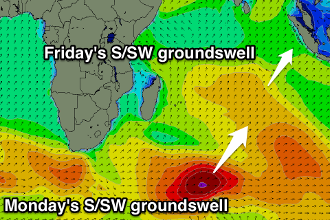
Ments: Solid swell Friday, backed up by another pulse Monday
Nias, Mentawai, South Sumatra forecast by Craig Brokensha (issued Tue 1st Jul)
Best Days: Every day over the coming period
This week and weekend (Jul 2 - 6)
Late last week's large pulse of SW groundswell with funky winds should of eased through the weekend and further into yesterday. A new SW groundswell should of filled in today though, offering inconsistent 5-6ft waves across the Ments under light to moderate SE winds (stronger in Southern Sumatra).
This swell is expected to ease through tomorrow and further into Thursday, with wave heights due to bottom out Thursday morning.
Friday's large S/SW groundswell has been upgraded a touch since last Thursday with the frontal progression generating the swell late last week and over the weekend coming in a touch stronger and broader than forecast.
This has resulted in the swell coming in earlier across the Ments, showing later Thursday ahead of a peak Friday morning to 6-8ft+ across exposed locations. Nias should see less size to 6-8ft with Sumatra offering more consistent sets above 8ft.
The swell should then ease through the night and drop through Saturday and further Sunday.
Next Monday onwards (Jul 7 onwards)
 Another large pulse of S/SW groundswell is due through Monday next week across the region, generated by a vigorous polar front that is currently strengthening south-east of Madagascar as it falls under the influence of a strong node of the Long Wave Trough.
Initially a fetch of gale to severe-gale SW winds will be generated through our swell window today and early tomorrow before the system pushes north-east towards Bali while weakening.
This should generate a large S/SW groundswell to a similar size (if not slightly bigger) as Friday's swell, coming in at 6-8ft+ in the Ments, 8-10ft in Southern Sumatra and 6-8ft+ around Nias.
The swell may be seen on dark Sunday but will fill in overnight and peak Monday morning.
A trailing front behind the initial vigorous swell generating system should soften the easing trend through Tuesday ahead of a more noticeable drop into Wednesday and Thursday.
Winds on Monday look to be generally variable but into the middle to end of next week a small trough/low deepening off the Sumatran coast looks to bring poor and fresh W/NW-NW winds.
We'll confirm this again on Thursday though.
16 day Mentawai forecast graph
16 day Nias forecast graph
16 day South Sumatra forecast graph

