Large easing swell over coming days, fun through next week
Nias, Mentawai, South Sumatra forecast by Craig Brokensha (issued Thu 26th Jun)
Best Days: Every day over the coming period
This week and weekend (Jun 27 - 29)
A very large and powerful SW groundswell should be currently building across the Mentawai region, talked about in detail for over a week now. This swell is expected to peak this evening, but build to 10-12ft+ later in the day across exposed spots in the Ments, with a touch less size around Nias and bigger bombs in South Sumatra.
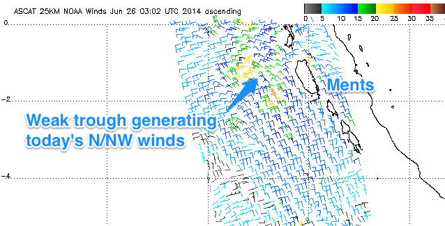
 The Northern Ments may have seen some funky W/NW-N/NW winds with a weak trough sitting just to the west of the region shown in satellite observations to the right.
Over the coming few days the large SW groundswell will drop away, easing from 10ft to possibly 12ft at exposed spots in the Ments early tomorrow, further down from 6-8ft+ Saturday morning before bottoming out Monday evening to 4-5ft+ or so.
The trough to our west will weaken causing early N/NW winds tomorrow to become variable into the afternoon and remain variable for the rest of the period.
Next Monday onwards (June 30 onwards)
A couple of medium-large SW groundswell pulses are due through next week, the first due on Tuesday ahead of a slightly bigger and better increase Friday.
The first swell has already been generated to the south-east of South Africa and should come in at an inconsistent 5-6ft across exposed spots in the Ments Tuesday.
A slightly better polar front pushing further north into the South-central Indian Ocean should produce a bigger pulse Friday to 6ft to occasionally 8ft across exposed spots into the afternoon.
From next weekend onwards there's nothing too major on the cards for our region, but medium levels of groundswell should keep exposed spots active. Check back Tuesday for the next update though.
16 day Mentawai forecast graph
16 day Nias forecast graph
16 day South Sumatra forecast graph

