Ments: Sizey now, smaller next week
Nias, Mentawai, South Sumatra forecast by Craig Brokensha (issued Thu 5th Jun)
Best Days: Every day over the coming period
This week through to Monday (Jun 5- 9)
A low point in swell should be seen today but it will only be short-lived, with a strong but inconsistent increase in SW groundswell due through tomorrow. The source of this swell is from a vigorous polar frontal progression south-east of South Africa and Madagascar and after providing pumping waves at Jeffreys Bay, the swell is marching towards us.
A peak through tomorrow afternoon/evening is due across the Ments with 6-8ft surf at exposed spots while Nias should see a similar peak but later in the day, holding into Saturday morning. South Sumatra is expected to offer a touch more size with 8ft+ waves at exposed breaks.
A steady drop in size is then due Saturday afternoon, but a reinforcing SW groundswell is due through Sunday afternoon, keeping large waves hitting exposed spots ahead of a secondary better pulse from the S/SW Monday afternoon.
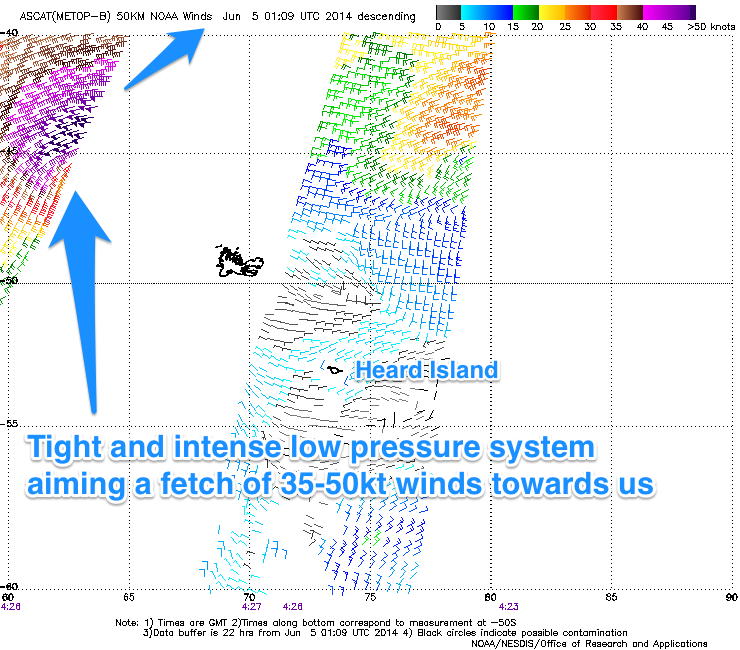
 Monday's swell will be more consistent than Friday/Saturday's but smaller as it is being generated by a tight but intense low pressure system moving through the Central Indian Ocean. Satellite observations confirm a fetch of 35-50kt SW winds being generated through our swell window (right), with a large long-period S/SW groundswell due to arrive through Monday and peak through the day.
The Ments should see 6ft+ surf at exposed breaks, with a touch less size in Nias and 8ft sets around Southern Sumatra. A steady drop in size is then due through Tuesday and further Wednesday with wave heights backing off to the medium size range.
Winds over the weekend and early next week should be generally light and variable but from Tuesday onwards weaker SE trades are due to develop, but not reach too much strength.
Next Tuesday onwards (Jun 10 onwards)
A distinct swing in swell direction will be seen into the second half of next week and beyond as a strong blocking high over the Western Indian Ocean focusses frontal activity more up through the South-eastern Indian Ocean and through our southern swell window.
A series of vigorous polar fronts will push up along this path generating large pulses of S/SW groundswell for Bali, but we'll see smaller side-band energy coming in from nearly the dead south and in the medium size range. We'll confirm this on Tuesday though.
16 day Mentawai forecast graph
16 day Nias forecast graph
16 day South Sumatra forecast graph

