Poor week, more options on the weekend
Eastern Tasmanian Surf Forecast by Craig Brokensha (issued Monday February 20th)
Best Days: Northern corners Saturday afternoon, Sunday
Features of the Forecast (tl;dr)
- Weak, building S windswell tomorrow with strong S/SW-S/SE winds
- Easing windswell Wed with S/SW tending E/SE then NE winds
- Building N/NE windswell later Thu with N/NW tending strong N/NE winds
- Small N/NE windswell Fri with strong N/NE winds, lighter and N/NW early
- Building N/NE windswell Sat with N/NW tending strong N/NE winds
- Fun, easing surf Sun with W/SW-NW winds
Recap
Small NE runners inside southern corners Saturday morning, tiny yesterday and today.
This week and weekend (Feb 21 - 26)
The coming week is benign, with troughy weather and poor winds not expected to be mixed with any real quality swell.
A trough will bring a strong S/SE change tomorrow kicking up a weak S'ly windswell to 2-3ft that looks to ease Wednesday from 1-2ft with an early SW breeze. A shift to the E/SE is due through the day and then NE into the afternoon.

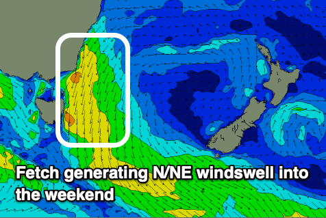
We then look at a weak but building N/NE windswell that should start to develop through Thursday as a strong high moves into the southern Tasman Sea, squeezed by an approaching low, come trough in the Bight.
Patchy, strong N/NE winds will be aimed through our swell window before broadening and increasing in strength on the weekend.
This should produce some weak N/NE windswell to 2ft or so late Thursday through Friday, with Saturday building further to 3ft+ late, peaking Sunday morning to a good 3ft to possibly 4ft (we'll review this Wednesday).
Winds will be generally poor and strong from the N/NE, lighter and more N/NW early with a great, offshore change Sunday as the trough moves across us. This looks to bring SW-NW winds, with the finer details nailed down through the next two forecasts.

