Try the beaches this week

Victorian Forecast by Craig Brokensha (issued Monday January 6th)
Best Days: Wednesday and Thursday mornings to the east, Sunday morning
Features of the Forecast (tl;dr)
- Fading surf tomorrow, mixed in with a low quality S'ly windswell
- Strong S winds early to the west, lighter E/NE to the east, freshening from the E-E/SE across all locations and then stronger SE into the PM
- Small mix of SE windswell and background W/SW energy Wed with fresh E/NE tending strong SE winds
- Fading surf Thu, tiny Fri with NE winds Thu (SE later), S/SE Fri
- Tiny Sat AM, with a new W/SW groundswell arriving later, peaking Sun
- N/NE tending late SE winds Sat, N/NE Sun ahead of a S/SW change
Recap
The weekend offered great waves across all locations with our reinforcing SW groundswell for Saturday coming in at a good 3-4ft on the Surf Coast with strong 6ft+ sets to the east under light offshore winds.
Yesterday was much more manageable on the exposed beaches to the east with a drop in swell and light offshore winds again.
Overnight a trough has brought an onshore change and conditions are now cold and a mess.

Saturday morning looking the goods
This week and weekend (Jan 7 - 12)
The coming period has improved for locations to the east of Melbourne, with today’s trough due to shift off to the north-east tomorrow as high pressure quickly fills in behind it.
This will see pre-dawn strong S’ly winds west of Melbourne though lighter E/NE winds to the east, freshening across all locations from the E-E/SE through the morning and then stronger SE into the afternoon.
Swell wise a mix of localised windswell and leftover swell from today don’t look to top 2ft on the Surf Coast with 2-3ft sets to the east.
Wednesday looks cleaner to the east under a gusty but easing E/NE breeze, shifting variable NE before late sea breezes kick in.
The Surf Coast is due to see some localised SE windswell to 2ft to occasionally 3ft while the Mornington Peninsula looks to come in at a similar size with some small, background swell energy.
It looks like the surf will bottom out into the end of the week with fading 2ft sets max on the exposed beaches to the east Thursday under morning offshores, near flat Friday with S/SE breezes.
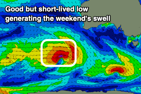
Saturday morning will start tiny again, while a new long-range W/SW swell is due into the afternoon, peaking Sunday.
It looks small to moderate in size, generated by a healthy low firing up to the south-west of Western Australia mid-week. The low will be strong but short-lived with a fetch of W/SW gales due to produce a fun kick in size Sunday to 3ft+ on the Surf Coast and 4-6ft to the east under early N/NE winds, possibly shifting S/SW with a trough.
Saturday afternoon is worth keeping an eye on as well with possible variable winds as the swell starts to build. I’ll confirm this Wednesday/Friday.
Comments
Leaving the sub tropical climes if QLD & venturing down to Surf Coast for the first time with the family on the weekend.
Forecast for Sunday looks promising. Apart from hiring foamies is there anywhere in Torquay which hires kids / longboards?
Next question could I get away with boardies / jacket or springy? Trying to get away from brining steamer / long arm springy..
You should be able hire from surf schools that are in town. You could get away with boardies and a jacket, but I would suggest a springy.
Mids not kids!!
Springy it is
Hey Dazzler, I have a pile of boards available you could borrow if you’re keen. Foamies (88s Crimes, Catch Surf, Corkies), LB, Midlengths
Better under someone’s feet than no ones feet :)
Only policy is you break it / ding it you repair / patch it (sun cure kit more than adequate in most circumstances)
Got a rabbits foot there if you really want to challenge yourself or the kids :)
Just shout out
NB just saw the Mids not kids correction hahaha
Extra NB ya could hit up Varuna for a demo board too pretty sure they hold em
Bump Dazzler
Will be between Torquay and further down the coast if still chasing a mid / LB from Friday to mid next week or beyond
6'7 up to about 7'6 plus a log but most in the range around 7ft
Stoked with this morning's wind forecast, such a tricky system with the trough sliding back west.
Its not often you see strong south winds swing abruptly to the east.
Kudos . . . though I wish you were wrong about the "localised windswell" bit. Very weak, short period "swell" not offering a lot of joy.
Great forecast Craigos. The morning report of a layday might of kept some in bed... unless they read the forecast