Strong south swell developing tomorrow, peaking Wednesday morning
Eastern Tasmania Surf Forecast by Craig Brokensha (issued Monday 16th April)
Best Days: South swell magnets Tuesday afternoon, Wednesday, Thursday morning
Recap
Small to tiny surf over the weekend with small levels of background SE groundswell.
Today’s Forecaster Notes are brought to you by Rip Curl
This week and weekend (Apr 17 - 22)
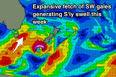
We've been under the influence of a zonal storm track through the weekend and today, but the storm track will take a more south-west to north-east angle this afternoon and into tomorrow, with a great fetch of gale to severe-gale SW winds generated in our southern swell window, projected up into the Tasman Sea tomorrow.
 This should generate a moderate-large S'ly groundswell event, building tomorrow and best aligned into Wednesday.
Tomorrow's swell will be very acute south and only get into true south swell magnets, with sets due to build to 4-5ft through the afternoon, while Wednesday looks best with sets to 4-5ft+, easing steadily through the day, smaller and down from the 3ft range Thursday, small to tiny Friday.
Winds will be favourable with a gusty W/SW tending lighter W'ly breeze tomorrow and then great W/NW tending N/NW winds on Wednesday. Thursday morning will be clean again, but bumpy into the afternoon with sea breezes as the swell becomes small.
Longer term there's nothing significant on the cards until the weekend when we may see some small NE windswell developing down the coast, but more on this Wednesday.

