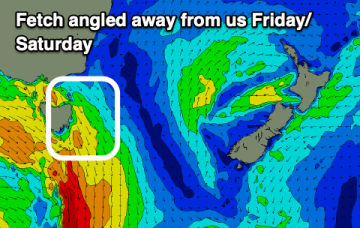
Approaching mid-latitude lows are too far north and too zonal (W-E) to offer any swell sources for NETas, so surf is expected to stay tiny/flat through the end of this week.
Primary tabs
/reports/forecaster-notes/eastern-tasmania/2023/06/14/tiny-surf-continues-little-more-look-forwards
freeride76
Wednesday, 14 June 2023
/reports/forecaster-notes/eastern-tasmania/2023/06/12/tiny-run-continues
Craig
Monday, 12 June 2023
Bring back La Niña. We're in a flat patch of surf with no real break in sight.
/reports/forecaster-notes/eastern-tasmania/2023/06/09/mostly-tiny-surf-ahead-right-through-next-week
freeride76
Friday, 9 June 2023
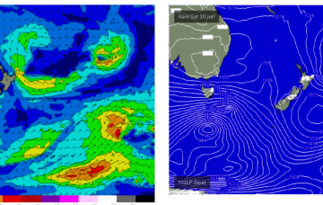
Not much chance for the weekend f/cast with a high to the north of the state and a low passing to the south driving a fresh W/NW to NW flow across the Island. No major swells are expected with the low being too zonal (W-E) to send much S swell wrap into the NE of the state.
/reports/forecaster-notes/eastern-tasmania/2023/06/07/peak-in-ne-windswell-tomorrow-run-small-surf
freeride76
Wednesday, 7 June 2023
The evolution of the current pattern has sped up compared to Monday’s notes with high pressure drifting towards the South Island and weakening and a low centred around the North Island moving NE. An approaching decaying front and inland trough will bring a strengthening N’ly flow tomorrow and peak in NE windswell with the end of the week seeing smaller, offshore conditions.
/reports/forecaster-notes/eastern-tasmania/2023/06/05/great-ne-windswell-ahead-week
freeride76
Monday, 5 June 2023
Models show a strong rebuild in wind-speeds through the fetch on Thurs with surf expected to peak in the 4-6ft range
/reports/forecaster-notes/eastern-tasmania/2023/06/02/s-pulse-sun-ne-windswell-builds-tues-next-week
freeride76
Friday, 2 June 2023
NE winds developing off the South Coast down to Bass Strait look like generating some useful NE windswell next week.

/reports/forecaster-notes/eastern-tasmania/2023/05/31/nice-s-swell-pulses-fri-and-sun-ne-swell-next
freeride76
Wednesday, 31 May 2023
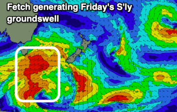
Another powerful front with gales to severe gales pushes NE into the Tasman Sat into Sun with a strong pulse of S swell making landfall across NETas at S facing beaches on Sun.
/reports/forecaster-notes/eastern-tasmania/2023/05/29/good-sly-swell-end-the-week
Craig
Monday, 29 May 2023
Friday looks the pick with some east potential for next week.
/reports/forecaster-notes/eastern-tasmania/2023/05/26/winter-wlies-and-small-s-swells-right-through
freeride76
Friday, 26 May 2023
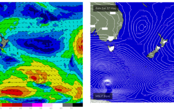
A monster low travelling under the continent is sending large swells to Victoria and is expected to send some minor S swell wrap up into the NE of Tas. The low and a high ridging in across the Australian interior maintain a brisk W’ly across the Island state.
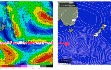
/reports/forecaster-notes/eastern-tasmania/2023/05/24/wintry-wlies-small-s-swells-wrapping-in
freeride76
Wednesday, 24 May 2023
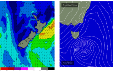
As we come to the end of Autumn we’ve got a typical looking winter synoptic pattern unfolding with a dominant high drifting over NSW bringing settled conditions with a very active Southern Ocean storm track spawning a strong cold front which will impact the state on Thurs. Most of the swell generating winds are better placed for Victoria with only small S swell wrap for NETas.