Large swells inbound with winds out of the south-eastern quadrant
Western Australia Surf Forecast by Craig Brokensha (issued Monday December 19th)
Best Days: Wednesday morning in the South West, Thursday morning all locations, Friday morning in the South West, protected spots Sunday/Monday
Features of the Forecast (tl;dr)
- Easing surf tomorrow with S/SE-SE winds ahead of strong sea breezes
- Large mix of SW groundswells building Wed, easing Thu
- Gusty SE tending S/SW winds Wed (E tending SW to the north)
- Gusty SE-E/SE winds Thu ahead of S/SW sea breezes (E tending SW to the north)
- Easing surf Fri and Sat with morning SE winds (E/NE to the north in the AM's)
- Oversized SW groundswell building Sun with S/SE tending S/SW winds, easing Mon with S winds
Recap
Great conditions continued through the mornings across all locations, slightly smaller into Saturday morning ahead of our new mid-period W/SW swell through the afternoon, best yesterday morning. Good, 4-6ft sets were seen in the South West with 1-2ft waves to the north, easing back a touch today to 4-5ft+, 1-2ft in Mandurah and 1-1.5ft across Perth respectively. Early offshore winds are now giving into sea breezes.


Two moods from this AM
This week and weekend (Dec 20 - 25)

The current swell will ease into tomorrow and winds will shift a little more to the S/SE-SE through the morning, creating less favourable though still favourable conditions on the magnets, easing 3-4ft sets are due with tiny waves across Perth and Mandurah. Sea breezes will come in late morning and be strong.
Moving into Wednesday we've got our mix of large SW groundswells due to fill in, with the first and most distant now looking redundant compared to the closer-range energy. In saying this the dual swells might create some weird phase double-ups which isn't ideal.
The source of both swells was the same storm, that being a strong polar low initially to the south of South Africa, pushing east while weakening before the remnants restrengthened in the Heard Island region. This restrengthening has generated a fetch of gale to severe-gale W/SW winds that are still continuing today, with a weakening trend due into this afternoon.
A large, close-range SW groundswell will be produced by the secondary intensification, with it due to build to 6-8ft Wednesday afternoon, easing from a similar size on Thursday morning in the South West. Sets to 2ft are due in Perth and Mandurah and a gusty, morning SE breeze is due in the South West (possibly E/SE at times) with E'ly winds further north, giving into strong afternoon sea breezes, similar in direction on Thursday with a tough less strength to the sea breeze.
The swell will ease through Friday, smaller again Saturday as winds hold mainly from the SE through the morning in the South West, E/NE to the north.
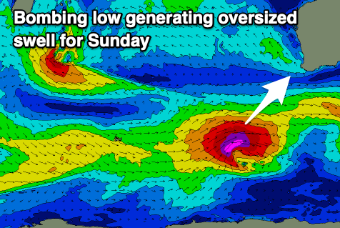
Into Sunday, a large new SW groundswell is on the cards, thanks to a tropical depression forming between Madagascar and South Africa drifting south-east and being absorbed into the westerly storm track.

This looks to result in the formation of a 'bombing' low, with the central pressure forecast to easily drop the required 24hPa in 24 hour period.
This will result in a rapid intensification and formation of storm-force W/SW winds through our south-western swell window, producing an oversized groundswell for Sunday.
The swell will build rapidly through the day and should reach 12-15ft across the South West into the afternoon, 4ft in Mandurah and 3ft on the sets in Perth. Conditions look a little average and best in protected spots with a gusty S/SE tending S/SW breeze, with S'ly winds persisting as the swell eases Monday. We'll have a closer look at this Wednesday though.

