Slowly improving conditions with fading surf

Victorian forecast by Craig Brokensha (issued Monday February 10th)
Best Days: Wednesday morning exposed beaches, Surf Coast Sautrday morning
Features of the Forecast (tl;dr)
- Easing SE windswell over the coming days, with a small mid-period SW swell for tomorrow and Wed AM, easing
- Moderate E/SE-E winds developing tomorrow AM (light at times on the MP) ahead of fresh sea breezes
- E/NE-NE winds Wed AM ahead of SE sea breezes
- Fading surf Thu with strong N/NE winds, tending N/NW early PM ahead of a late SW change
- Building mid-period SW swell Fri PM, peaking Sat with W/NW tending fresh S/SW winds Fri, gusty W-W/NW Sat AM, strong SW into the PM
- Moderate sized S/SW-SW swell Sun with strong SW tending S/SW winds (oustide chance of early W winds Surf Coast)
- Easing swell Mon with moderate S/SW winds (oustide chance of early W winds Surf Coast)
- Fresher S/SW winds Tue with a building SW groundswell later, peaking Wed
Recap
The weekend was mostly a write-off surf wise with persistent, strong onshore winds that only eased temporarily on Saturday afternoon but not enough to clean up conditions for a paddle.
Yesterday was a mess with strong south-east winds and a building windswell that’s holding today along with slightly better but still mostly poor winds. Strong cross-shore E/SE winds are favouring selected spots to the east, but the swell is coming from the wrong direction.
This week and weekend (Feb 11 - 16)
All the current swell is out of the south-east, generated by the interaction between an inland trough and strong high moving slowly east, just south of Tasmania.
This has produced strong east-southeast to south-east winds through Bass Strait that will slowly back off through tomorrow but more so Wednesday as the high continues east and pressure gradients relax.
There’ll be a small mid-period SW swell in the mix tomorrow and Wednesday morning, generated by a weak polar frontal system moving along the polar shelf the last couple of days, with a small 2ft wave due on the Surf Coast, 3ft+ to the east.
This is a little more promising for a surf on the magnets with winds due to swing E-E/SE through tomorrow morning but remaining moderate in strength, creating still average conditions.
Wednesday morning is the pick with winds finally swinging true offshore from the E/NE-NE, holding until mid-afternoon ahead of SE sea breezes.

Come Thursday, strong N/NE winds will create clean conditions but with fading sets from only 2ft or so to the east, tiny on the Surf Coast.
Moving into the end of the week, and an approaching mid-latitude low is due to drift south-east from the Bight and strengthen, projecting a fetch of strong to gale-force W/SW-SW winds through our south-western swell window.
This will then be followed by an elongated polar front pushing up on the tail of the low, with back to back pulses of SW swell due into later Friday but more so Saturday, with the secondary pulse for Sunday.
Later Friday/Saturday’s swell looks to come in at 3ft+ on the Surf Coast with 4-6ft waves to the east but with morning W/NW winds Friday, shifting fresh S/SW into the afternoon.
Saturday morning looks OK with a gusty W-W/NW breeze, shifting strong SW through the day, with Sunday seeing unfavourable SW tending S/SW winds with more size to 3-5ft and 6ft+ respectively to the west and east of Melbourne.
There’s a chance for lighter W winds on the Surf Coast early Sunday but we’ll review this through the week.
The swell will back off steadily into Monday as winds linger out of the S/SW, fresher Tuesday with even smaller surf.
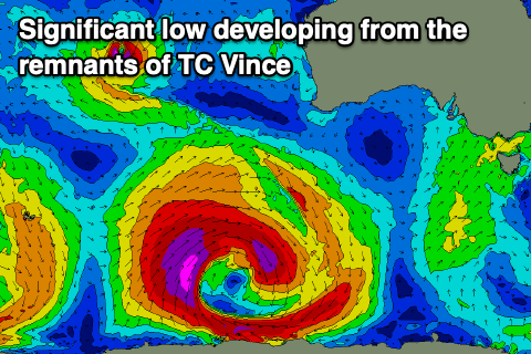
Longer term we could see Tropical Cyclone Vince which is in the middle of the Indian Ocean tracking south and being absorbed into the westerly storm track, then deepening into a broad, polar low low to the south-west of Western Australia this weekend.
A moderate to possibly large SW groundswell is likely Tuesday/Wednesday from this source, but more on this Wednesday.
Comments
strong N/NE winds, tending N/NW early PM ahead of a late SW change
Sums it up. Week after week.
I must admit I am over these persistent SE gales, with only a 30 second period of lighter winds midweek. Bring on Autumn.
Whaddya talking bout. It’s a cool 10 knot Westerly right now!!
Briefly at 1:00 pm? Ace. By the time I could get down, it was a 25 knot easterly. Hope you got some.
Sarcasm undetected. It was howling on the back beaches all day from the SE. Just a classic South Channel reading
Hah hah, well played. I suffer from sarcasm awareness deficit (SAD). Can dish it but miss it. I checked the Baywinds graph and thought I had missed something.
Cyclonic last few days, don’t even want to leave the house let alone worry a getting a wave lately