Cleaner conditions for the South Coast but with fading size

South Australian forecast by Craig Brokensha (issued Monday February 10th)
Best Days: Keen surfers South Coast tomorrow morning, Wednesday morning and Friday morning, Mid Coast for the keen Friday and Saturday, Mid Coast next Tuesday afternoon/Wednesday
Features of the Forecast (tl;dr)
- Small, easing S/SE windswell tomorrow with a small mid-period S/SW swell in the mix, both fading Wed
- Mod-fresh NE tending E/SE then lighter SE winds tomorrow, mod-fresh NE tending E/NE winds Wed
- Tiny Thu with strengthening W/NW winds (building windswell on the Mid Coast)
- Mod-large mid-period W/SW swell Fri with fresh SW winds, possibly lighter early on the Mid and W/NW down South
- Easing swell Sat, with some new moderate sized mid-period S/SW swell for the South Coast Sat/Sun
- Gusty S/SW winds Sat, fresh S/SE Sun
- Mod-large SW groundswell building next Tue, peaking overnight, easing Wed
- SE tending stronger S/SE winds
Recap
Our new pulse of SW groundswell seen into Friday dropped back through Saturday with clean 1-1.5ft sets on the Mid Coast, tiny into yesterday.
The South Coast saw a bit of size but with terrible conditions thanks to strong, persistent south-east winds and building levels of S/SE windswell.
This morning conditions have improved with winds backing off and swinging more E’ly, along with a fun, peaky S/SE windswell to 3-4ft or so.
This week and weekend (Feb 11 - 16)
All the current swell is out of the south-southeast, generated by the interaction between an inland trough and strong high moving slowly east, just south of Tasmania.
As the high continues east, the pressure gradient will relax and swing more northerly but with a drop in S/SE windswell.
There should be be a small mid-period S/SW swell in the mix tomorrow, fading Wednesday morning, generated by a weak polar frontal system moving along the polar shelf the last couple of days.

This should make for peaky 2ft waves tomorrow off Middleton, fading Wednesday from 1-2ft with tiny to flat conditions inside the gulf.
Winds will shift NE tomorrow morning, tending E/SE and then weaker SE into the afternoon with Wednesday seeing mod-fresh NE tending fresh E/NE winds.
Come Thursday, strengthening W/NW winds are due as a mid-latitude low moves in from the west.
This low will form to the south-west of Western Australia today with a good fetch of strong W/SW winds projected through The Mid Coast’s swell window before weakening on approach to us, through the Bight.
We should see some building windswell Thursday from the low moving in and across us, but Friday should offer a moderate-large sized pulse of mid-period W’ly swell to 3ft on the Mid Coast with fresh, lingering SW winds. There is a chance for lighter S/SE winds at dawn but we’ll review this on Wednesday.
For the South Coast, the west swell won’t provide much size but the backside of the low should kick up some new swell to 3ft+ with a 50/50 chance of early W/NW winds Friday, while a more elongated, stronger polar front projecting up on the back of the low should produce more sizey levels of S/SW swell Saturday/Sunday to 3-5ft.
Unfortunately winds will remain onshore out of the S/SW on Saturday, tending more S/SE through Sunday but the Mid Coast will become tiny by the time it fully cleans up on Sunday.
Saturday looks doable with choppy conditions and easing 1-2ft surf.
Into next week we’ve got a general south-east wind regime, but a strong new SW groundswell is due into Tuesday afternoon, easing Wednesday.
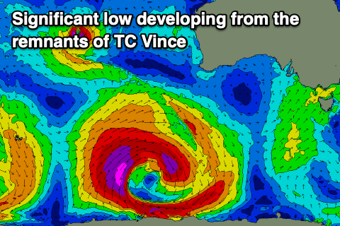
The source is another tropical cyclone being absorbed into the westerly storm track. In this instance, Tropical Cyclone Vince which is in the middle of the Indian Ocean, is forecast to track south before being absorbed into the westerly storm track, then deepening into a broad, polar low to the south-west of Western Australia this weekend.
A moderate to possibly large SW groundswell is from this source, but more on this Wednesday.
Comments
Do you foresee a break in the SE pattern before the end of Feb ?
There should be, but for how long is uncertain. The back end of the month does look a bit better.
Thanks Craig. Also, could someone give the cams a clean? Can't see a thing. Maybe some rain-x or some other kind of spray or coating would help?
There's been nothing to see down that way for months...
Yes Goolwa, Day street and Cliffs cams often completely blurred for days on end. I know it’s reflective of the shite onshores of late but gets pretty frustrating when forking out for the service…