Great conditions with fun swells
Western Australia Surf Forecast by Craig Brokensha (issued Wednesday December 14th)
Best Days: This morning South West magnets, South West in the mornings through early afternoon Friday through Wednesday next week, Perth/Mandurah Sunday morning and Thursday week
Features of the Forecast (tl;dr)
- Fading surf into tomorrow AM
- Inconsistent SW groundswell building tomorrow PM, holding Fri, with a reinforcing mid-period W/SW swell Sat PM, easing Sun
- Strong E/SE-SE winds tomorrow morning, S/SE into the PM (S/SW Perth and Mandurah)
- Strong E/SE winds Fri AM, easing into the mid-PM, S/SE into the PM (S/SW Perth and Mandurah)
- Fresh E/SE winds Sat AM, easing into the mid-PM, S/SE into the PM (S/SW Perth and Mandurah)
- Easing surf Sun PM with fresh E/SE winds ahead of PM sea breezes
- Easing surf Mon with gusty E/SE winds and late AM sea breezes
- SE tending S/SE winds on Tue
- Building moderate + sized, inconsistent SW groundswell Wed with strong S/SE winds
Recap
Clean, but small to tiny surf yesterday, building to 3ft on the sets across the South West during the day, easing from a similar size this morning. The small wave breaks have been the pick in the South West.

Small sets this AM
This week and weekend (Dec 15 - 23)
We'll see the small swell currently in the water across the South West bottoming out tomorrow morning ahead of some new, long-period energy arriving into the afternoon.

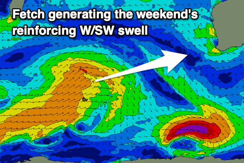
This swell and follow up energy through Friday, Saturday and Sunday were and are still being generated by a flurry of distant but healthy frontal activity to the south-east of South Africa since late last week.
It'll be inconsistent but we should see sets to 4-5ft across the South West from mid-late afternoon tomorrow (1-1.5ft Mandurah and Perth), holding through Friday and Saturday, ahead of secondary pulse Saturday afternoon/Sunday morning. This secondary pulse will be a touch more consistent and a little west in nature, generated by a fetch of strong W/SW winds north of the Heard Island region today and tomorrow.
A little stronger 4-6ft surf should be seen in the South West Saturday afternoon and Sunday morning, with infrequent 1-2ft sets in Perth and Mandurah.
Winds tomorrow will be fresh and out of the E/SE-SE through the morning, shifting S/SE and strengthening through the afternoon in the South West, S/SW to the north.
Strong E/SE winds are expected on Friday, creating great conditions deteriorating mid-late afternoon and similar in direction to Thursday afternoon.
Come the weekend, morning offshore E/SE winds will continue, holding until mid-afternoon Saturday but becoming sea breezy earlier in the day Sunday. This will provide plenty of time for a couple of surfs with the fun sized swell.
Monday will be clean again as we see a stationary high sitting under the country, squeezed by an inland low. Fresh and gusty E/SE winds should hold out until late morning, with easing surf from the weekend, smaller Tuesday but with morning SE winds.
Moving into Wednesday winds, look to shift S/SE as the low drifts south, squeezing the north-west flank of the high as it drifts east, and we should see a new, inconsistent SW groundswell filling in.

This groundswell will originate in our far swell window again, generated by a strong polar low firing up south of South Africa, with a fetch of severe-gale to storm-force W/SW winds forecast to project slowly east into the end of the week.
The low will weaken to the north-west of the Heard Island region, leaving the swell to travel onwards to us. It'll be inconsistent but we should see good sets building to 6ft to possibly 8ft in the South West through Wednesday afternoon, 2ft in Mandurah and 1-2ft across Perth but with strong S/SE winds. The swell is expected to ease through Thursday and winds are a little unsure so we'll have a closer look at this on Friday.
Longer term continued frontal activity to the north of the Heard Island region should produce fun swells into late week/weekend, but check back Friday for an update.

