A windy period with a good swell next week

Western Australia Surf Forecast by Craig Brokensha (issued Friday March 25th)
Best Days: Protected spots tomorrow in the South West, Sunday morning metro beaches (protected spots in the South West), Monday and Tuesday afternoons in the South West, Wednesday, Thursday morning in the South West
Features of the Forecast (tl;dr)
- Small, inconsistent mid-period SW swell building tomorrow with gusty E/SE-SE tending strong S/SE winds, easing Sun with strong S/SE-SE winds
- Small NW swell for Sun AM in Perth and Mandurah
- Small backgroundswells Mon and Tue with strong E/SE winds
- Large SW groundswell for Wed AM, easing into the PM and much smaller Thu. Strong E-E/NE winds
Recap
Great conditions but small, leftover surf across the South West yesterday, tiny in Perth and Mandurah.
Today a slight uptick in small mid-period SW swell hasn't really provided much with windy, slow 2-3ft sets on the South West magnets.
This weekend and next week (Mar 26 – Apr 1)
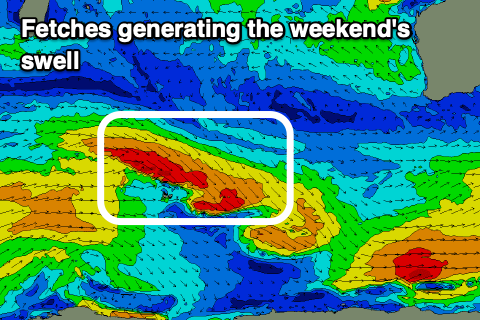 While today's swell was never expected to be great, we should see some slightly better, inconsistent SW swell energy for the weekend, generated by a slim fetch of W/NW gales projecting south-east through our swell window this week.
Building sets to 4-5ft are due across the South West into tomorrow afternoon, easing from 3-5ft on Sunday with no major size due in Perth or Mandurah from this direction.
Winds look favourable for the South West and fresh from the E/SE-SE now, shifting stronger S/SE into the afternoon as ex-Tropical Cyclone Charlottes drifts slowly south while weakening. Sunday will be windy and not ideal with strong S/SE-SE winds holding all day.
Coming back to ex-TC Charlotte and it looks like any NW swell will be very minimal in size. Currently Charlotte is west of the Carnarvon region but well offshore and generating a fetch of N/NE gales aimed into the Indian Ocean.
During today it will drift south, with a very brief fetch of strong N/NW winds due to be aimed through our swell window this evening and tomorrow morning.
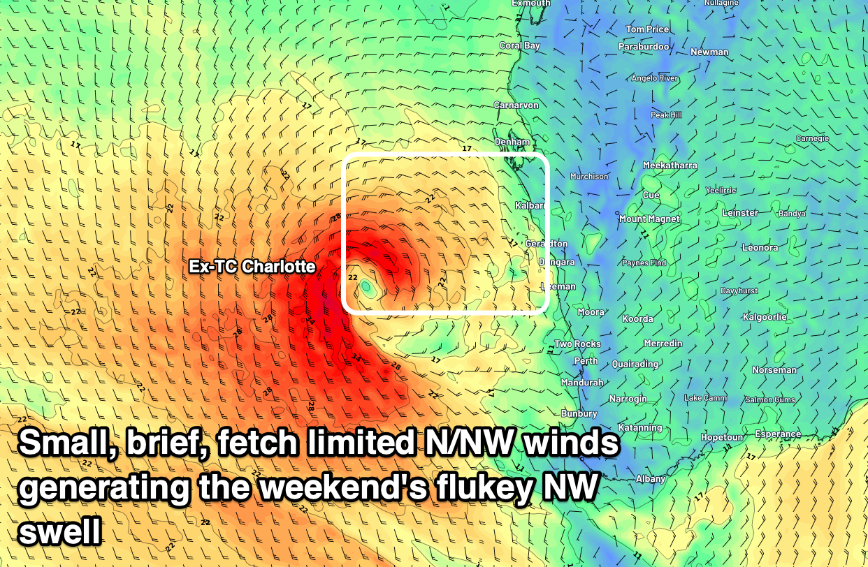
This should produce a small pulse of weak NW swell for Sunday morning that might produce a 1-2ft wave, which is better than nothing. Locations further north of Perth will likely see a touch more size but nothing of any major substance.
We're now not due to see much in the way of acute S'ly swell from the remnants of Charlotte early next week, with a high quickly sliding in under the state, swinging winds E/SE into Monday and Tuesday, straighter E'ly on Wednesday.
Now, we've got a couple of small, background SW swells due Monday and Tuesday, likely not above 4ft in the South West, ahead of a large S/SW groundswell Wednesday.
 The source of this groundswell will be a strong polar low forming south-east of the Heard Island region tomorrow evening. A great fetch of severe-gale W/NW winds are expected to be generated through our southern swell window, with the swell arriving overnight Tuesday and peaking Wednesday to 8ft+ in the South West, 2ft to occasionally 3ft in Mandurah and 2ft in Perth. Winds will be gusty but great and strong from E, tending E/NE through the afternoon.
The swell will ease rapidly owing to the location of the storm and it moving under the country, out of our swell window fairly quickly, with clean but easing 4ft sets on Thursday.
Longer term there's a few smaller swells due into next weekend, but we'll have another look at this on Monday. Have a great weekend!
Comments
Hi Craig, will there be any swell down south on Saturday before the wind fires up?
Yeah should be 4ft in the morning I feel.
Hi Craig,
Any idea when the mr cam will be back online?
Yes I too am wondering it’s been off a loooong time now …..
Is a camera of any real benefit these days?
It is for down here Nicko74. Good to see what swell is in the water as i'm 15 minutes away from actually seeing the ocean. Saves alot of fuel.
Having said that, doesn't need to be on a surf break. Just plonk it on an unsurfable open ocean bombie somewhere along there to give an indication of size and direction.
Margs cam should be upgraded and repaired in the coming weeks.
Ive had about 15 storm warnings from an app off a different site but still no rain or storms.
Charlotte seems to be moving north again and according to windy.com is near shark bay at the moment.
We are supposed to be getting a 2-3 foot swell from it but i havent bothered checking the spots that handle north swells. Woke up too late when the winds had turned south.
Hopefully charlotte doesn't hit this town on its way back south again. This town cant handle storms at the moment after seroja.
Your sounding much like abc 5am news report regarding rainfall. SW, Gascoyne, Western SW, eastern Gascoyne, eastern southwest, western Gascoyne blah blah less in the blah blah. Coming, continuing blah blah. Up down blah blah.
No rain fell mid south west after sunrise this morning.