Make the most of tomorrow
Western Australia Surf Forecast by Craig Brokensha (issued Monday March 7th)
Best Days: Today, tomorrow in the South West, Thursday morning on the South West magnets
Features of the Forecast (tl;dr)
- New, mid-period SW swell tomorrow with strong E'ly winds, easing ahead of afternoon S/SW sea breezes
- Easing swell Wed with light to moderate E/NE winds and later S/SW sea breezes
- Small, slow swell Thu and Fri with morning E/NE winds (fresh Fri)
- W'ly change moving in Sat with fresher SW winds Sun but no new swell
Recap
Fun surf all weekend with a stronger pulse of swell for Saturday to the 5ft range across the South West, back to a smaller 3-4ft yesterday. Perth and Mandurah were clean but tiny.
Today is a little smaller again and best from late morning as strong onshore winds eased off allowing the surf to improve.
This week and weekend (Mar 8 - 13)
 We've got a clean week of surf across the South West with tomorrow being the biggest with a new pulse of mid-period SW swell, easing from the afternoon and small into the end of the week.
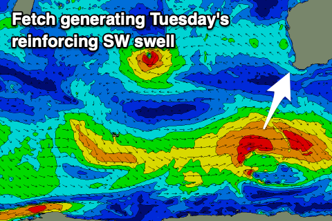
This swell has been generated by a healthy polar low firing up east of the Heard Island region on the weekend, with it now pushing east and out of our swell window, under the country.
We should see sets kick back up to 4-5ft across the South West tomorrow morning, easing a touch through the day, then dropping back from 3ft+ into Wednesday morning. Perth and Mandurah will remain tiny and conditions will be windy but clean with a strong E'ly offshore, easing through the middle of the day ahead of afternoon S/SW sea breezes.
A lighter E/NE offshore is due on Wednesday along with later forming sea breezes but hunt the swell magnets for a wave around Margaret River.
 Unfortunately into the end of the week we'll see the swell bottom out with no significant swell generating frontal activity due through our swell windows besides a late forming polar low, keeping 2ft to maybe 3ft sets on the magnets Friday morning. Conditions will remain clean though with morning E/NE winds, gusty on Friday.
Moving into the weekend, a trough will bring an onshore change during Saturday (with possible variable winds early ahead of it) but there'll be no decent swell in the water.
Unfortunately there's no significant swell generating systems showing at all until later next week when a strong mid-latitude low might fire up north-east of the Heard Island region. Winds look a little suspect with this swell as well with troughy activity due to move in with it from the west. Therefore make the most of tomorrow and today's offshore winds.

