Good swell but average winds tomorrow
Western Australian Surf Forecast by Craig Brokensha (issued Friday February 18th)
Best Days: Protected spots tomorrow, Sunday morning in the South West, Thursday and Friday mornings in the South West
Features of the Forecast (tl;dr)
- Moderate-large, reinforcing SW groundswell for tomorrow AM, easing steadily there after, smaller and fading Sun
- Light-mod S/SE winds tomorrow AM, shifting strong S/SW-SW into the PM
- Fresh SE tending strong S winds Sun
- Fading surf Mon with gusty E/SE-E morning winds
- Small, mid-period S/SW swell Tue with S/SE winds
- Inconsistent, small, mid-period SW swell Thu/Fri with fresh morning SE winds
Recap
A little slow to start off yesterday but our strong, new SW groundswell started to show with more vigor mid-morning, building to 6ft+ through the day on the exposed reefs with tricky, strong offshore winds, easing late morning ahead of workable sea breezes. This was a little under the expected peak to 8ft on the sets.
The swell has eased back quickly this morning leaving slower 4-5ft sets on the magnets with strong offshore winds. The swell was a little under expectations further north as well with Mandurah building to 1-2ft, with 1-1.5ft sets in Perth.
This weekend and next week (Feb 19 - 25)
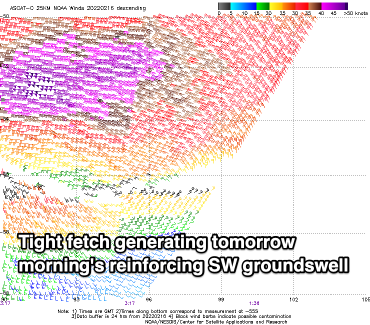
With the drop in swell seen today on the back of yesterday’s groundswell, we’ve got a good reinforcing pulse of SW groundswell due across the South West tomorrow morning.
This was generated mid-week by a fetch of fast moving, tight severe-gale to storm-force W’ly winds racing through our swell window.

The South West should see a good kick back to 6ft+ tomorrow morning with 2ft sets in Mandurah and 1-1.5ft waves across Perth.
Winds are still looking less than ideal for the exposed breaks with a trough swing pre-dawn offshore winds tending S/SE around first light, giving into strong S/SW-SW sea breezes.
The swell will ease rapidly owing to the fast movement of the low through our swell window with Sunday due to drop steadily from 3-4ft on the South West magnets with a fresh morning SE breeze. Perth and Mandurah will be tiny.
 Moving into early next week there isn't’ expected to be any real size left Monday with a gusty offshore E/SE-E wind but fading 2ft sets max in the South West. A small, mid-period S/SW swell from a weak front may be seen Tuesday to 2-3ft on the south swell magnets but with poor S/SE winds as another trough moves through.
Dual tropical cyclones in the central and western Indian Ocean will suppress any major storm activity firing up through our swell window, with another, small mid-period S/SW swell due late week, spreading off an unfavourably aimed polar front. This swell will be a touch better than Tuesday’s with sets to 3-4ft due Thursday and Friday, along with slowly improving but strong SE winds.
Longer term there’s still nothing too major on the cards, but we’ll have a closer look at this on Monday. Have a great weekend!

