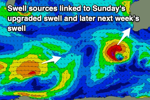
Upgrade in the weekend's swell
Western Australia Surf Forecast by Craig Brokensha (issued Friday January 14th)
Best Days: Tomorrow morning in the South West, protected spots Sunday in the South West Sunday, Monday morning Margs and Mandurah, Tuesday morning in the South West, next Friday morning in the South West
Features of the Forecast (tl;dr)
- Small mid-period S/SW swell tomorrow with light E/NE tending W winds
- Stronger S/SW swell building Sun, peaking into the PM with fresh S/SE tending stronger S-S/SE winds
- Easing S/SW swell Mon with fresh E/SE tending S/SW winds
- Inconsistent, mid-period swell building Thu, holding through Sat AM with the cleanest conditions being found Fri and Sat mornings
Recap
Bumpy, choppy small to tiny surf across the state yesterday while today our first pulse of new mid-period SW swell has filled in with decent conditions and 3-4ft sets across the South West magnets. Perth and Mandurah were 1-1.5ft but wind affected.
This week and weekend (Jan 15 - 21)
Today's pulse of swell is a little ahead of schedule but it doesn't change the size expected through tomorrow with similar 3-4ft sets due to continue across the Margaret River region with a window of light E/NE winds through the morning. There might be the odd bigger sneaky one in the mix while Perth and Mandurah are set to remain tiny.
Winds will shift onshore late morning so surf before then.
 After downgrading on Wednesday we've now got a fresh upgrade regarding Sunday afternoon's swell, generated by a strengthening low, south-west of us today and tomorrow.
A good fetch of strengthening W/SW winds will reach gale-force from the SW tomorrow morning, with a better pulse of S/SW swell due to build through Sunday and peak into the afternoon.
The South West should build to the 6ft range with 1-2ft sets likely across Mandurah, 1-1.5ft in Perth.
Unfortunately winds will be fresh from the S/SE, stronger into the afternoon/evening and tending more S'ly. Try protected spots. Monday looks nice and clean as the swell eases with a fresh E/SE offshore and dropping sets from 4-6ft across the South West magnets, 1-2ft Mandurah and 1-1.5ft Perth.
Tuesday will be clean again but the swell small and fading ahead of a low point Wednesday.
Our inconsistent, mid-period SW swell for later next week is on track, generated by a broad, slow moving polar low that will push up and across the Heard Island region on the weekend, stalling while aiming similar strength winds more towards Indonesia.
A prolonged though relatively small and inconsistent swell is due from this source, arriving Thursday and persisting through Saturday.
The South West should build to 4-5ft on Thursday afternoon, easing from a similar size Friday morning, then 3-5ft on Saturday. Conditions look a bit dicey Thursday but cleaner Friday and Saturday with morning E'ly breezes.
Longer term there's still nothing major on the cards but we'll have another look at this Monday. Have a great weekend!

