Slow outlook continues
Western Australia Surf Forecast by Craig Brokensha (issued Monday January 3rd)
Best Days: Margs tomorrow morning, Wednesday morning and protected spots Friday late morning
Features of the Forecast (tl;dr)
- Reinforcing mid-period S/SW swell filling in tomorrow, peaking into the afternoon, easing Wed
- Fresh SE winds tomorrow ahead of stronger sea breezes, E/SE-SE Wed AM ahead of strong sea breezes
- Fading surf Thursday with gusty S/SE morning winds
- Small, mid-period S/SW swell building Fri with strong SE tending S/SE winds, easing Sat with S/SE winds
Recap
Poor surf Saturday but our new, mid-period S/SW swell kicked in for Sunday as winds swung offshore creating fun surf in the 4ft range across the South West and 1-1.5ft further north.
Today the swell has eased off a touch with winds from the SE, favouring slightly protected spots in the South West.
This week and weekend (Jan 4 - 9)
With yesterday's mid-period S/SW swell easing temporarily today, we'll see one final pulse of less consistent, slightly stronger (though still mid-period) energy filling in tomorrow and peaking through the afternoon.
The source of this swell was a burst of stronger W/SW winds on the tail of the progression linked to Sunday's swell and we should see infrequent 4-5ft sets across the South West south magnets through the day, 1-1.5ft in Mandurah and Perth through the afternoon.
An easing trend is then expected from Wednesday, further into Thursday, reaching a low point early Friday.
Winds tomorrow should be favourable and fresh from the SE, stronger from the S/SE into the afternoon with Perth and Mandurah seeing strong S/SW sea breezes.
Wednesday will be a touch cleaner with E/SE-SE winds through the morning as the swell eases back from the 4ft range on the sets.
 Give Thursday a miss as winds shift S/SE and the swell fades.
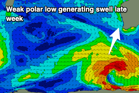
Into the end of the week, a new mid-period SW swell is due across the state but again it won't be overly sizey and generated by broad tough relatively weak polar low forming south-west of us Wednesday.
The low will be poorly structured and hardly produce any decent swell generating winds, with a weak fetch of strong W/SW winds firing up generating a small 4ft+ of swell for later Friday, easing Saturday. Perth and Mandurah aren't expected to see any major size and winds will be gusty from the SE Friday morning and S/SE on Saturday. Not ideal.
Longer term there's still nothing significant on the cards so try and make the most of the coming windy swell days.

