Good run for the beaches coming up
Victorian Surf Forecast by Craig Brokensha (issued Friday 11th March)
Best Days: Beaches to the east tomorrow morning, Sunday morning, Monday through Thursday mornings beaches to the east
Features of the Forecast (tl;dr)
- Easing mid-period SW swell tomorrow with variable winds (light SE Surf Coast) ahead of sea breezes
- Moderate sized + SW groundswell Sun AM with light N/NE tending S/SE winds (NE Surf Coast)
- Easing SW groundswell Mon with light NE tending S/SE winds
- Reinforcing SW swell Tue with NE tending S/SE winds, easing Wed with E/NE tending S/SE winds
- Fresh NE winds Thu with fading surf
- New W/SW swells building from next weekend and into the following week with E winds
Recap
A slight drop in swell through yesterday across all locations with a variable wind east of Melbourne and fun conditions, poor and fresh onshore to the west.
Today winds are moderate across all locations and out of S'th creating bumpy though workable conditions along with a new pulse of mid-period SW swell (3ft+ Surf Coast magnets). Winds should stay the same most of the day with surfable options into the afternoon and evening.
This weekend and next week (Mar 12 – 18)
Today's reinforcing pulse of mid-period SW swell is due to ease into tomorrow and winds will become lighter, tending variable east of Melbourne but likely light SE across the Surf Coast.
 Size wise, easing sets from 2ft to occasionally 3ft are due on the Surf Coast magnets, though slow with the early high tide, and the 4ft range to the east. Sea breezes will kick in through the day so surf before lunch.
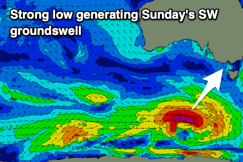
Moving into Sunday, our good pulse of new SW groundswell is on track, with a strong but small polar low forming south of Western Australia yesterday. A good fetch of gale to severe-gale W/SW winds have and are still being generated through our swell window, with it due to arrive Saturday evening, easing Sunday morning from the 4ft range on the Surf Coast magnets, 3-4ft most spots with 6ft surf on the Mornington Peninsula.
This is a touch too big for the beaches to the east and conditions look to be great with a light N/NE offshore (NE Surf Coast) before sea breezes kick in.
Monday looks more approachable on the beaches to the east with the easing swell from 4ft or so, 2-3ft on the Surf Coast with a morning NE breeze ahead of fresh afternoon S/SE sea breezes.
Our reinforcing pulse of mid-period SW swell for Tuesday is on track along with morning NE winds, generated by a weaker trailing fetch of W/SW winds on the backside of the current strong low.
This should keep 2-3ft sets hitting the Surf Coast magnets with 4ft+ sets to the east, easing Wednesday with a morning E/NE breeze.
 The swell will bottom out into the end of the week with offshore winds persisting Thursday ahead of a trough and change into the evening, persisting from the SE on Friday.
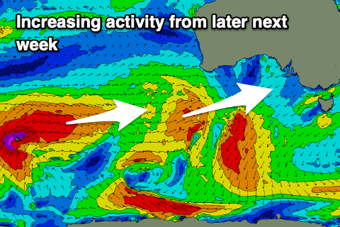
Winds unfortunately look to persist out of the eastern quadrant into next weekend and early the following week along with some good, new W/SW groundswell arriving from a strong frontal progression firing up towards Western Australia.
This progression will be held at arms length from us due to the blocking high bringing the easterly winds but we're looking at moderate sized + pulses of swell with the beaches to the east fairing best. More on this Monday. Have a great weekend!


Comments
Will the easterlies ever stop craigos?
yes, will they ???
Shall we take bets on how long until that one lonely day on 25/3 that is currently showing as NW wind for SC flips to SE… I’m going with the next model update.
Good solid swell today Craigos. Here’s to a decent autumn.
Got love throaty barrels over the ledge. Good swell good period great waves. Fingers crossed the pattern continues to swing. It’s been a hard year (or two) for all vicco surfers all things considered