Fun peaky waves on the beaches
Victorian Surf Forecast by Craig Brokensha (issued Monday 28th February)
Best Days: Exposed beaches tomorrow morning, Wednesday morning, selected spots Thursday morning, Friday morning exposed beaches
Features of the Forecast (tl;dr)
- Inconsistent SW swell building Tue with light-moderate E/NE tending fresh SE winds, peaking Wed with strong E'ly tending fresh SE winds
- Slightly smaller, less consistent groundswell Thu with strong E-E/SE tending SE winds, easing Fri with moderate NE tending SE winds
- Low point in swell Sat with variable tending S winds
- Building mid-period SW swell and larger, localised S windswell Sun with strong S tending SE winds, holding Mon with strong E/SE winds
Recap
Poor waves across the Surf Coast on the weekend with junky levels of windswell and onshore winds, workable for the keen to the east in protected spots. This morning the swell is smaller and cleaner on the Mornington Peninsula but for the keen.
This week and weekend (Mar 1 - 6)
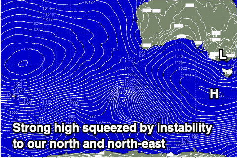
 We've got a windy week of waves which will be fun east of Melbourne as a strong high sitting south of us is squeezed by inland instability and a deepening coastal trough off the East Coast.
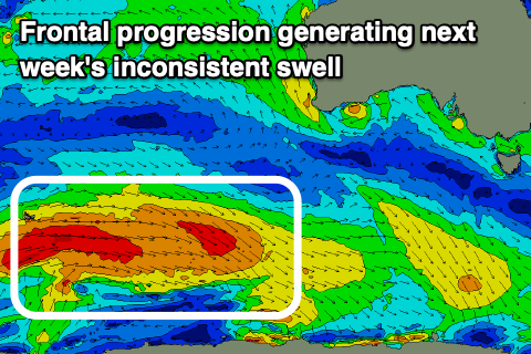
Winds tomorrow look lightest and light to moderate from the E/NE in the morning along with our inconsistent, building SW swell which is due to peak Wednesday. The source of this swell and Thursday's energy was discussed last week, generated by a broad, slow moving polar frontal progression shown middle right.
In the morning expect inconsistent 3ft+ waves on the Mornington Peninsula tomorrow, 2ft on the sets across the Surf Coast but building to 3-5ft and 2ft to occasionally 3ft respectively. Sea breezes will create average conditions from late morning so get in before lunch.
 As the instability to our north-east tracks south closer towards us, winds will strengthen from the E on Wednesday with 2-3ft sets on the Surf Coast, mixed in with some south-east windswell and 4-5ft on the Mornington Peninsula.
Into Thursday a slight drop in size and consistency is due, but a long-range groundswell should steady wave heights through the day across both coasts to 2ft to occasionally 3ft on the Surf Coast, 3-5ft to the east along with a fresh and gusty E-E/SE breeze, shifting SE into the afternoon.
As we move into Friday winds will ease and shift NE with small, fading sets from 2ft on the Surf Coast and 3ft+ to the east.
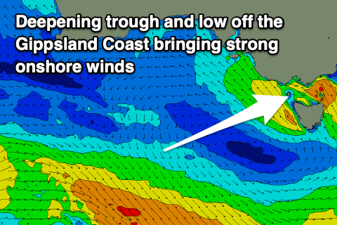
 A low point in swell activity is due Saturday but as we move into Sunday a trough moving in from the west will deepen and strengthen south-east of the Gippsland coast, directing strong S tending SE winds Sunday, E/SE on Monday along with some poor, local windswell across the coast.
Some new, mid-period SW swell is due to be in the mix Sunday and Monday but it'll be hard to decipher under the onshore winds and local windswell.
Unfortunately the trough looks to maintain SE winds through most of next week, but we'll have a closer look at this on Wednesday.


Comments
Living the dream, we are.
Yet another disgusting forecast for sc surfers. . Only a little better for the east coasters.
Have been some unreal windows down this way but only for an hour of so and have to be right on it.
Been pumping the whole summer, today was shit, tomorrow looks good but probably too big for the MP
cant believe you keep saying this!
Cmon Finnbob really? Are you saying better than a normal summer ? Hot northerlys etc.
seemed to be a little swell here and there but with ave winds or good winds but no swell. Generally.
Rarely would the 2 line up. Yes I’m on the Surfcoast so different requirements but I watch the weather and reports closely. Out of 10 for summer??
"Out of 10 for summer??"
For summer beach weather 10/10
For groms learning to surf 9/10
For diving & spearfishing 8/10
For good surf on the MP 3/10
Haha, just ruffling memlas little feathers,
7/10 for cooking nipple hights
1/10 for chest-beating barrel hero's
10/10 for crowds
Heard you got pretty good red hot chilli pepper song the other Finnbobba!
Heard you got pretty good red hot chilli pepper song the other Finnbobba!
Haha, wasn't really under it, it was close to it but a little east towards the surf god. Inside out the other morning with the tomato king had some leg burners I will send you some footage of ya old abode on the telephone.
why do i have the feeling us mexcians are going to get skunked the labour day long weekend:(
projection of current trend?
sadly yes
Also, what's going on with this "off-line surfcam" syndrome ? Will all cameras succumb ? Is this also a consequence of the dreadful Easterly ?
Anyone find some waves on the MP that weren't closing out on the sets today, besides gunna.
Portsea through to Shit rock was Shit.
bom way off with there wind strength forcast today....just like sunday water looked like an oil slick far from 25kts ese wind.