Tiny most of the week, better weekend
Southern Tasmanian Surf Forecast by Craig Brokensha (issued Monday July 8th)
Best Days: Keen surfers Friday, beaches Saturday morning, keen surfers Tuesday and Wednesday mornings
Features of the Forecast (tl;dr)
- Easing S/SW swell tomorrow with N/NW winds ahead of a shallow, PM S/SE change
- Moderate sized W/SW groundswell for Sat with N/NW winds, easing Sun with dawn NW tending SW winds mid-AM
Recap
Plenty of swell over the weekend following Friday afternoon’s increase in size, with strong 3ft sets seen Saturday as the new SW groundswell peaked.
Yesterday still came in at 2ft while a secondary reinforcing S/SW swell has maintained 2-3ft sets into today. Conditions are lumpier this afternoon thanks to winds shifting a little more NE.
This week and weekend (Jul 9 - 14)
Make the most of the current, easing swell as the outlook for the week ahead is very slow.
We should see fading 1-2ft sets tomorrow with clean conditions during the morning, giving into a S/SE change during the afternoon as a trough slides through.
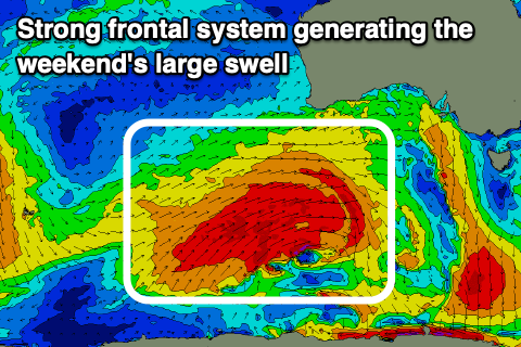
We’ll then be looking a tiny surf until the weekend, when some strong W/SW groundswell will impact the state.

The origins will be a strong Southern Ocean frontal progression firing up to the south-west of Western Australia during the middle of this week, with a great fetch of gale to near severe-gale W/SW winds being projected east towards us.
The location of this storm isn’t ideal but still south enough to generate some decent size for Clifton, with it arriving early Saturday morning and jumping quickly to 3ft. It’ll be a little inconsistent but clean and smooth all day with a N/NW offshore, while a SW change is due to move in Sunday morning.
Following this swell, fading surf is due into the middle of the week ahead of some possible S/SE swell but with poor winds as a low forms east of us in the southern Tasman Sea. More on this Wednesday.

