Very active period with strong swells inbound
Southern Tasmanian Surf Forecast by Craig Brokensha (issued Friday April 8th)
Best Days: Beginners all weekend, selected spots Monday morning, Tuesday morning, Wednesday, Thursday
Features of the Forecast (tl;dr)
- Tiny W/SW swell Sat and Sun with gusty N/NE winds Sat and strong N/NE tending weaker W/NW winds Sun
- Strong pulse of W/SW groundswell Mon AM (easing) with fresh W/SW tending S/SW winds
- Fading swell Tue with N/NW tending W/SW winds
- Mod-large SW groundswell Wed AM (easing) with NW tending weak SE winds
- Easing surf Thu with NW tending SE winds
- Moderate sized SW groundswell Fri with S winds
Recap
The reinforcing pulse of S/SE groundswell yesterday came in a little stronger than expected with great 3-4ft sets across Clifton, though easing rapidly into today, back to 1-2ft.
This weekend and next week (Apr 9 - 15)
Into the weekend inconsistent background W/SW swell energy should create tiny waves for beginners with sets to 1ft+ across Clifton and with favourable winds.
A gusty N/NE breeze should blow all day tomorrow, with Sunday seeing strong N/NE winds ahead of a shallow W/NW change.
This change will be linked to a deepening low pushing in and under us, with a brief fetch of gale to severe-gale W'ly winds generated off angle to our main swell window.
This should still produce a tricky spike in W/SW groundswell for Monday morning, coming in at 3ft across Clifton (much bigger at more exposed locations), easing through the day and tiny Tuesday.
 Winds still look average unfortunately with a fresh W/SW breeze Monday morning, shifting more S/SW through the day with Tuesday cleaner under a N/NW breeze, shifting W/SW into the afternoon.
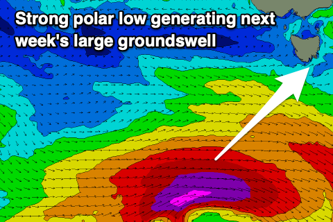
Moving into Wednesday and we've got an upgrade in the expected SW groundswell with a significant polar low due to fire up south-west of us on Sunday evening.
A fetch of severe-gale to storm-force W/SW winds will generate a moderate-large S/SW groundswell for Wednesday, coming in at 4-5ft+ in the morning under a NW offshore. The swell will ease through the day with weak sea breezes, while Thursday looks clean and fun as the swell eases.
Following this weaker frontal activity should produce some reinforcing, moderate sized swell Friday but more on this next week. Have a great weekend!

