Small swells with winds mostly out of the north-east
Southern Tasmanian Surf Forecast by Craig Brokensha (issued Friday February 25th)
Best Days: Tomorrow morning, Tuesday through Thursday selected spots
Features of the Forecast (tl;dr)
- Easing mid-period W/SW swell tomorrow with light N tending stronger E/NE winds
- Tiny Sun with N'ly winds and S/SE sea breezes
- Tiny Mon with increasing S/SE winds
- Inconsistent W/SW swell Tue with moderate NE tending strong E/NE winds
- Inconsistent W/SW swell easing slowly Wed and Thu with strong NE winds Wed and moderate N/NE tending strong NE winds Thu
Recap
Tiny onshore surf yesterday with similar, bumpy 1ft waves into today. Some new W/SW swell is due into the afternoon but the weekend should provide cleaner conditions.
This weekend and next week (Feb 26 – Mar 4)
This afternoon's small increase in mid-period W/SW swell should reach 1-2ft across Clifton, generated by a weak, less than favourably aligned frontal progression the last two days. The swell should ease back from 1-2ft tomorrow morning and winds will improve, tending light N'ly before strengthening from the E/NE through the afternoon.
Sunday will see light N'ly winds ahead of sea breeze but tiny levels of swell.
Monday will be a lay day as a trough moves through bringing SE winds, possibly light in the morning but with no new swell.
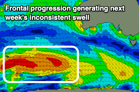
 Into Tuesday though we'll see some inconsistent mid-period W/SW swell filling in, generated by a healthy though distant polar frontal progression moving in from the west today and tomorrow.
An elongated fetch of strong to near gale-force W-W/NW winds will be generated in our medium range swell window, generating inconsistent 2ft sets when it fills in Tuesday, holding a similar size Wednesday morning then easing from a slow 1-2ft on Thursday.
Winds will be an issue and only favour selected spots, moderate NE tending strong E/NE on Tuesday with strong NE winds holding most of Wednesday and Thursday though shifting N/NE on Thursday morning.
The size will fade into the end of the week and we'll be looking at some possible new swell for the following weekend and beyond as a frontal progression starts moving in from the west late week. The models diverge around this at this stage so more on it Monday. Have a great weekend!

