Fun swell for Wednesday, larger swell for the weekend
Southern Tasmania Surf Forecast by Craig Brokensha (issued Monday 31st October)
Best Days: Tuesday, Wednesday, Thursday morning, Sunday morning
Recap
Tiny clean waves for Saturday, smaller again Sunday with less than ideal winds for Clifton.
Today a better W/SW groundswell has filled in with nice clean 2ft sets across Clifton.
This week (Nov 1 - 4)
We've got a couple of decent pulses of W/SW groundswell due over the coming days, but Wednesday is the pick.
Currently an elongated fetch of strong to gale-force W/SW winds are extending from below WA up towards our West Coast.
The fetch currently just off our west is a little too far north and west in nature to generate any major size tomorrow.
A persistent 1-2ft of W/SW swell is likely all day tomorrow with offshore NW tending W/NW winds.
The more polar fetch of W/SW gales projecting up towards Victoria through today and tomorrow should produce a better aligned and larger W/SW swell for Wednesday morning to a fun 2-3ft across Clifton.
Conditions are due to be good all day with a fresh W/NW breeze. Expect a drop in size through the afternoon, further from 2ft on the sets Thursday under NW winds. Friday is due to be tiny.
 This weekend onwards (Nov 5 onwards)
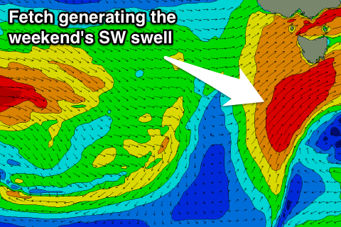
Into the weekend, a strong cold outbreak is expected across the state again, with snow strong onshore winds and a moderate sized SW swell.
This will be due to the low moving across us, projecting a fetch of gale-force SW winds up into us Saturday moving off to the east Sunday.
An afternoon in size is due Saturday with strong onshore winds, peaking Sunday morning to 4-5ft or so Sunday morning. Winds look to swing back offshore from the W/NW Sunday morning, even possibly NW, ahead of a W/SW change. We'll have a closer look at this Wednesday.

