Mostly poor conditions for the South Coast with small waves on the Mid

South Australian forecast by Craig Brokensha (issued Wednesday February 5th)
Best Days: Mid Coast tomorrow and Friday morning, South Coast for the keen tomorrow, Mid Coast later Friday and Saturday morning
Features of the Forecast (tl;dr)
- Moderate + sized mix of W/SW-SW swells building later today, peaking tomorrow with E/SE winds ahead of sea breezes (E/NE down South early)
- Easing surf Fri with strengthening S/SE winds
- Mod-large sized SW groundswell for later Friday afternoon, easing Sat wit strong SE-S/SE winds
- Easing swell Sun with fresh SE-S/SE winds
- Moderate sized S/SE windswell in the mix for the weekend, easing Mon
- E/NE tending S/SE winds Mon
- Small to tiny Tue with N/NE winds
Recap
Monday’s swell held in a little better than expected through yesterday with the Mid Coast continuing to 1.5ft mostly with early variable winds, strengthening from the SE through the day, creating improving conditions. The South Coast saw early W/SW winds and 2-3ft of swell, deteriorating once winds shifted more south and strengthened.
Today the Mid Coast is clean but tiny while the South Coast is seeing a junky, localised windswell.
This week and next (Feb 6 - 14)
Later today but more so tomorrow, we should see our mix of inconsistent, long-range SW groundswell filling in, along with some better, more consistent mid-period swell out of the W/SW-SW.
The mix of swells were generated by a strong low that formed south of South Africa earlier last week, traversing the Southern Ocean towards us while slowly weakening and then having one final re-intensification south-west of us yesterday.
The Mid Coast should come in around 2ft tomorrow (magnets), easing back to 1ft to possibly 2ft on the favourable parts of the tide Friday, with the South Coast offering 4ft waves tomorrow across Middleton, easing from 3ft on Friday.
We should see winds ease and tend E/NE tomorrow morning across the South Coast creating OK conditions for the keen while the Mid Coast should see an E/SE offshore ahead of relatively weak sea breezes.
Friday will then see strengthening S/SE winds kick back in, favouring the Mid Coast and creating poor surf down South.
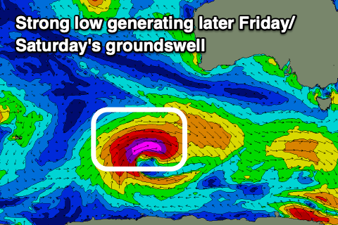
Now, into Friday afternoon and Saturday morning, a strong pulse of moderate + sized SW groundswell is due.
As touched on in Monday’s notes, the source is a strong low that formed south-west of Western Australia yesterday thanks to the remnants of Tropical Cyclone Elvis drifting south-east from Madagascar, and then being absorbed into the westerly storm track.
A great fetch of severe-gale to storm-force W/SW winds have been generated in our south-western swell window and this should produce a strong kick in size later Friday afternoon to 4-6ft across Middleton, peaking overnight and easing steadily from 4-5ft on Saturday morning.
The Mid Coast should see 1-2ft waves across the magnets on the favourable parts of the tide later Friday, easing through Saturday from 1-2ft and local winds will favour the gulf with strong SE-S/SE winds on Saturday, fresher SE Sunday morning before shifting S/SE again through the day.
All this wind will also kick up a moderate sized, poor S/SE windswell for the South Coast on the weekend, slowly easing into next week as winds slowly improve. A mix of easing swells from a peaky 3ft+ is expected Monday morning, with Tuesday coming in cleaner but smaller and weaker to 1-2ft.
Unfortunately the rest of the week looks minimal size wise (until Friday) and with onshore winds from Wednesday.