Tricky end to the week, good swell for next
South Australian Forecast by Craig Brokensha (issued Wednesday September 25th)
Best Days: Mid Coast tomorrow, South Coast Friday morning and early Saturday, South Coast for the keen Monday morning, both coasts Wednesday/Thursday
Features of the Forecast (tl;dr)
- Small W/SW swell tomorrow with strong but easing S/SE-SE winds down South, E/SE-SE inside the gulf ahead of sea breezes
- Small-mod sized S/SW swell Fri AM, easing with N/NE-NE winds ahead of E/SE sea breezes
- Fading surf Sat with gusty N/NE-N winds
- Building W/SW swell Sun, peaking later on the Mid, Mon AM down South
- Strong NW tending W/SW winds Sun, W/NW tending W/SW Mon
- Large W/SW-SW groundswell building Tue with strong but easing SW winds
- Swell peaking Wed AM, easing with local offshore tending variable winds
Recap
The South Coast offered excellent waves yesterday with super clean conditions and 6-8ft of SW groundswell during the morning, easing into the afternoon as winds tending more variable. The Mid Coast performed well with clean 2ft+ surf most of the day, with the swell still maintaining that size this morning with early light winds ahead of a stronger change.
The South Coast was smaller but also a little lumpy/bumpy early with light winds, now a mess with a stronger change.

Great surf yesterday
This week and weekend (Sep 26 - Oct 4)
Today’s trough and change will clear east tomorrow with winds due to ease and shift more SE. The South Coast will still be a mess with fresh but easing S/SE-SE winds, while the Mid Coast looks fun and clean.

A small background W/SW swell is due to maintain 1-1.5ft sets, generated by a weak frontal system projecting towards Western Australia, with Friday coming in smaller.
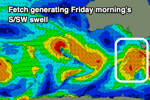
Down on the South Coast though Friday, a fun new pulse of S/SW swell is due, generated by a healthy fetch of strong S/SW winds projecting towards Victoria/Tasmania today.
This should maintain 3ft sets across Middleton, easing through the day and then fading back from 2ft on Saturday.
Winds are due to swing around to the N/NE-NE on Friday morning, creating great conditions ahead of E/SE sea breezes, clean all day Saturday with a gusty N/NE-N breeze.
Sunday looks tiny across both coasts in the morning but a cold front moving through during the day should kick up some localised swell for the Mid Coast as winds shift from strong NW to W/SW. 2ft of swell is likely but with average conditions, easing Monday from a similar size.
The South Coast should see a tight low generating a pulse to 2-3ft on dark Sunday and more so Monday morning along with W/NW tending W/SW winds.

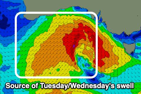
Of greater significance is a stronger mid-latitude frontal system projecting up and under the Bight from Sunday through early next week, with it due to produce a moderate-large sized W/SW-SW groundswell for Tuesday afternoon and Wednesday morning.
Fetches of gale to severe-gale winds should see the Mid Coast peaking around the 3ft range with Middleton coming in at 6ft+. Strong but easing SW winds are due Tuesday as the swell generating front clips us, with Wednesday seeing a high quickly moving in, bringing local offshore winds from the north-east, similar Thursday as the swell eases.
Longer term, a less consistent W/SW groundswell is likely for the next weekend, but more on this Friday.

