Large surf persisting until Wednesday
South Australian Forecast by Craig Brokensha (issued Friday September 20th)
Best Days: Protected spots South Coast today, tomorrow and Sunday, both coasts Monday and Tuesday, Mid Coast for the desperate Wednesday
Features of the Forecast (tl;dr)
- Large SW groundswell building through today, peaking into the PM with strong W-W/NW winds
- Large easing swell tomorrow with strong W/NW-W winds
- Temp drop in size Sun with fresh to strong but easing W/NW winds
- Large SW groundswell for Mon, peaking through the day with light W/NW-NW winds down South (possibly N/NE early across the Mid Coast), tending variable across both regions into the PM
- Large SW groundswell Tue with local offshore winds and weak/variable sea breezes
- Easing surf Wed with strong S/SE winds
- Easing surf Thu with E/SE tending S/SE winds
Recap
Yesterday was poor across all regions with a W/SW wind and tiny swell inside the gulf, choppy across the South Coast.
Today the Mid is bigger but choppier with no real quality while a large SW groundswell is filling in down South with cross-offshore winds and sets to 6ft. This swell should continue to build towards 8ft on the sets through the day as winds strengthen a touch more.

Solid surf this morning with a bit of wind
This weekend and next week (Sep 21 - 27)
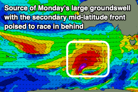
Today’s large increase in SW groundwell was generated throughout this week by a strong polar low that projected up slowly towards us, generating severe-gale W/SW winds.
The elongated nature of the system will result in the swell still coming in large tomorrow morning as it eases, with 6-8ft sets early across the South Coast, 2ft inside the gulf.
Strong W/NW winds will persist all day, favouring protected spots on the South Coast while creating poor conditions inside the Mid Coast.
A temporary low point in swell is due Sunday morning, but the next swell generating system will approach, bringing an afternoon increase in mid-period energy ahead of a larger SW groundswell Monday.
This will be produced by a strong polar low firing up to the south-southwest of Western Australia today, projecting a great fetch of severe-gale to storm-force W/SW winds towards Tasmania.
Middleton is likely to be 4-5ft on Sunday, possibly kicking later with Monday coming in at 6ft to possibly 8ft while the Mid Coast persists around 2ft on the favourable parts of the tide.

A secondary pulse of large, reinforcing SW groundswell is then due Tuesday morning to a similar size (2ft+ Mid Coast), easing into the afternoon. This will be generated by a secondary fast tracking mid-latitude system pushing in from the west Sunday/Monday, producing fetches of severe-gale to storm-force W/NW winds.
Looking at the local winds and Sunday should see a slight reduction in wind strengths, holding from the W/NW with Monday set to see lighter W/NW-NW winds across the South Coast, possibly N/NE early inside the gulf but variable into the afternoon. This will be the time to target a surf on the Mid Coast, when conditions become cleaner after lunch Monday.
Tuesday looks great as well with an E/NE offshore across the Mid Coast, variable into the afternoon and N/NE tending N/NW winds across the South Coast.
By Wednesday a trough looks to bring strong S/SE winds around dawn with easing surf across all locations, likely 1-1.5ft across the Mid Coast for the keen. The South Coast looks to improve later week along with a moderate sized SW swell, but more on this Monday. Have a great weekend!

