Varying conditions for the weekend, strong swell next week
South Australian Surf Forecast by Craig Brokensha (issued Friday July 26th)
Best Days: Today South Coast, early tomorrow South Coast, both coasts Sunday morning, South Coast Monday morning, Thursday, Friday
Features of the Forecast (tl;dr)
- Moderate + sized mix of W/SW and SW swells tomorrow with strong W/SW-SW winds (W/NW early in Victor)
- Easing swell Sun with S/SE tending SW winds on the Mid, W/NW tending SW down South
- Smaller Mon with N/NE AM winds
- Moderate sized W swell for later Tue, fading Wed
- N/NE tending N/NW winds inside the gulf Tue/Wed, N/NE tending E/NE down South
- Mod-large sized W/SW groundswell building late Wed, easing Thu
- N/NE-NE winds Thu
Recap
The Mid Coast remained choppy and wind affected with small levels of swell, while the South Coast was small and to 2ft yesterday, increasing a little into the afternoon and coming in at a slow but good 3ft on the sets this morning.
This weekend and next week (Jul 27 - Aug 2)
The weekend ahead all revolves around the size of the swell coming from a tricky but strong mid-latitude frontal system that’s currently moving across us.

The majority of the fetch around the storm is weak, but a tight low pressure centre is generating W’ly gales that may even reach severe-gale during today in the South Coast’s south-western swell window.
We should see a mix of mid-period W/SW swell and short-lived SW spike for the South Coast tomorrow with 2-3ft sets due inside the gulf, 3ft to occasionally 4ft across Middleton, easing from 2ft and 3ft respectively on the Mid and South Coasts Sunday morning.
Local winds tomorrow will remain poor for the South Coast with strong W/SW-SW winds (likely W/NW early around Victor), with Sunday seeing S/SE winds on the Mid, W/NW down South before reverting onshore through the day.
Monday looks great for the South Coast with a N/NE offshore and smaller fading 2ft of swell down South.
Moving into Tuesday, we’ve got a tricky new W’ly swell due into the afternoon, fading Wednesday.
The source is flukey, unfavourable with an east-southeast tracking frontal system from the Indian Ocean due to generate W/NW winds through our western swell window.
The Mid Coast may see 1-2ft sets later Tuesday, easing Wednesday with small 2ft sets max across Middleton under N/NE tending E/NE winds down South, N/NE tending N/NW on the Mid both Tuesday and Wednesday.

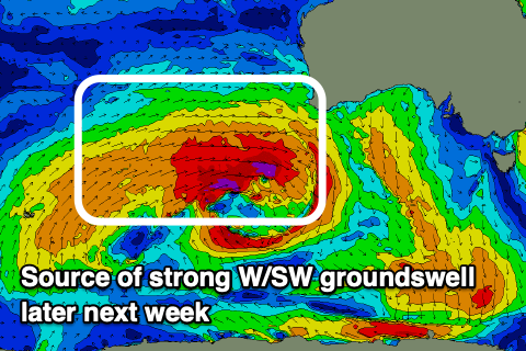
Later in the day Wednesday but more so Thursday morning, a larger W/SW groundswell is due, generated by a significant storm firing up from the Southern Ocean, towards Western Australia/Indonesia.
We’re set to see a great fetch of severe-gale to storm-force W/SW winds generated through our medium-range swell window, with moderate to large levels of W/SW swell due to arrive late Wednesday, peaking overnight and easing Thursday.
The Mid Coast should offer 3ft sets on the favourable parts of the tide with 4-5ft+ sets across Middleton. Winds at this stage look great and out of the N/NE-NE but we’ll confirm this on Monday. Have a great weekend!

