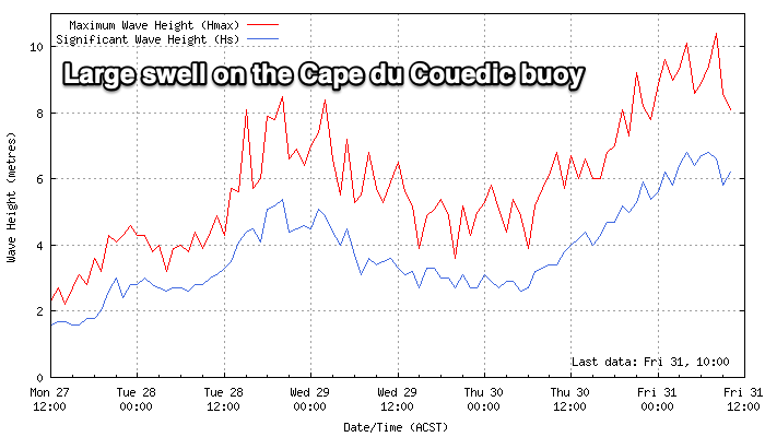
Rapid improvement in conditions tomorrow
South Australian Surf Forecast by Craig Brokensha (issued Friday May 31st)
Best Days: South Coast today, both coasts tomorrow, South Coast Sunday, Tuesday both coasts (Mid Coast afternoon), Wednesday morning Mid Coast, later next week South Coast
Features of the Forecast (tl;dr)
- Large W/SW groundswell today, tending SW and then S/SW while easing tomorrow
- Light, local offshore winds tomorrow with weak sea breezes
- Smaller Sun with light, local offshore winds, tending variable
- Low point in swell Mon with N/NE tending N/NW winds
- Moderate sized, inconsistent W/SW groundswell building Tue, peaking in the PM, easing Wed
- Light, local offshore winds Tue with a PM S/SE change
- Easing swell Wed with S/SE winds
- New, inconsistent SW groundswell later Thu, peaking Fri with N/NE tending variable winds
Recap
Conditions were blustery on the coast yesterday with periods of strong offshores down South and more favourable, cleaner conditions with 3ft of swell. The Mid Coast was still 2ft but choppy with the cross-shore winds, increasing into the afternoon with some building windswell.
Today a strong mid-latitude low is moving across us bringing a semi-stormy 3-4ft of swell to the Mid Coast with 3-4ft waves also down South and more due as winds shift more W/SW. More on this below.
This weekend and next week (Jun 1 - 7)
A strong mid-latitude low has moved across us while generating a mixed fetch of strong to severe-gale W/SW winds in our western swell window, with gale to severe-gale S/SW winds wrapping in around its southern flank.

This is generating today’s stormy increase in swell on the Mid Coast with the South Coast building off the southerly fetches and we should see a peak in both W/SW and S/SW swell energy this afternoon, easing tomorrow.
With the low moving off to the east we’ll see winds ease off this evening and swinging back locally offshore tomorrow morning, N/NW-N down South and E/NE across the Mid Coast, with weak sea breezes into the afternoon.
The Mid Coast looks to ease back quickly from an early 2-3ft with Middleton still offering 4ft sets, down further from 1ft+ and 3ft respectively Sunday morning.
Sunday’s winds look to again be favourable, N/NE down South and E/SE across the Mid Coast ahead of variable sea breezes.
A low point in swell is due Monday with 1-2ft leftovers across Middleton but with great, moderate to fresh N/NE tending lighter N/NW winds for the magnets.
Into Tuesday, a new inconsistent W/SW groundswell is due to fill in, peaking through the afternoon and then easing Wednesday.
It’s being generated by a strong progression of mid-latitude frontal systems pushing up towards Western Australia in our medium to long-range swell window.

Various fetches of gale to a times severe-gale W/SW winds will be projected through our western swell window, with the Mid Coast due to reach 2ft+ into the afternoon with Middleton building to 3-4ft.
Winds look good for this well again and locally offshore, though a trough will bring a S/SE change through the afternoon, favouring the gulf.
S/SE winds might linger into Wednesday as the swell eases but we’ll confirm this Monday.
Into the end of the week, a good, long-range SW groundswell is on the cards as winds shift back to the north-eastern quadrant, but check back here on Monday for the latest. Have a great weekend!

