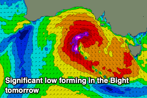
Stormy west swell to end the week, improving on the weekend
South Australian Surf Forecast by Craig Brokensha (issued Wednesday May 27th)
Best Days: Today South Coast, tomorrow South Coast, Friday South Coast, Saturday both coasts, Sunday and Monday mornings South Coast, Mid Coast next Tuesday
Features of the Forecast (tl;dr)
- Easing W/SW groundswell tomorrow with strong N tending N/NW winds (possibly easing later down South)
- Building NW windswell aross the Mid Coast tomorrow
- Mod-large W/SW swell Fri (peaking later down South) easing Sat
- Strong but easing W/NW winds Fri, variable tending locally offshore Sat AM
- Smaller Sun with E/NE-NE tending SE winds
- Inconsistent, small W/SW swell Mon with N/NE tending SE winds
- Better W/SW groundswell Tue, but inconsistent with SE-S/SE winds
Recap
What a couple of great to epic days of surf across both regions.
Following Monday afternoon’s glass-off, yesterday provided great clean surf in the 3ft range across Middleton, building into the afternoon with the fresh pulse of long-period W/SW groundswell to 4-5ft as conditions remained clean and glassy.
The Mid Coast was a good 2ft to occasionally 3ft through the morning with a touch of northerly windswell texture, while the afternoon saw the swell kick to a stronger 3ft with glassy conditions before filling up late.
Today the South Coast is the pick with sets still in the 4-5ft range (easing) while the Mid is still 2-3ft but wind affected and not great.

Solid and glassy yesterday arvo
This week and weekend (May 30 - Jun 2)
The current, large W/SW groundswell will ease back through this afternoon and further tomorrow as winds strengthen from the N tending N/NW, possibly easing into the late afternoon down South.
Easing 2-3ft sets are due across Middleton while the Mid looks to ease back from 2ft but with a building NW windswell taking over and reaching 3ft or so into the later afternoon.
We then look at the mid-latitude forming in the Bight and pushing in and across us on Friday.
This low will form early tomorrow, with a mixed fetch of strong to gale-force W/SW winds due to be projected through the Mid’s swell window, while into the afternoon, stronger severe-gales are likely more in the South Coast’s swell window.

What we should see Friday is a large spike in close-range W/SW-SW swell wit the Mid Coast coming in at 3-4ft with strong but easing W/NW winds, while the South Coast should build through the day, reaching 4-5ft later in the day with good condition for protected spots as the W/NW winds ease through the day.
The swell will fade steadily into Saturday thanks to the quick movement of the low to the east, with easing 4ft surf down South, and easing 2-3ft sets across the Mid Coast. This will be with variable tending local offshore winds thanks to the low clearing east, creating decent conditions across both regions.
Sunday will become smaller but with an E/NE-NE offshore ahead of SE sea breezes.
Moving into next week and we’ve got favourable winds from the north-easter quadrant due Monday, while a trough moving in from the east on Tuesday might bring less favourable SE winds. Beyond this the outlook diverges so we’ll confirm this again on Friday.
Swell wise, some new, moderate sized W/SW groundswell energy is due Monday but more so Tuesday across the region, thanks to a strong but disjointed frontal progression firing up in the Indian Ocean. This will favour the Mid Coast with sets to an inconsistent 2ft likely. More on this Friday.

