Fun surf developing for both regions
South Australian Forecast by Craig Brokensha (issued Wednesday May 1st)
Best Days: South Coast tomorrow every morning this period, Mid Coast Sunday and Monday
Features of the Forecast (tl;dr)
- Slight drop in swell tomorrow with light-mod E-E/NE winds ahead of sea breezes
- Moderate sized mid-period S/SW swell for Fri AM, easing into the PM and smaller Sat
- Local S/SE windswell also in the mix later week
- E/NE tending S/SE winds Fri, variable offshore Sat and Sun AMs
- Mix of W/SW groundswells filling in Sun with local offshore tending gusty S/SE-SE winds Sun, similar Mon
- Easing size on the Mid Coast Mon, holding down South, easing Tue
- N/NE tending S/SE winds Tue
Recap
A new lift in mid-period SW swell provided 1-1.5ft surf on the Mid Coast yesterday with bumpy, though doable 3ft to occasionally 4ft sets on the South Coast.
This morning the swell is similar in size down South but with fresher E-E/SE winds, creating average conditions, clean but only 1ft in the gulf.
This week and next (Apr 2 - 10)
The current mid-period swell energy is due to ease back into tomorrow morning back to the 3ft on the sets across Middleton and with a light to moderate E-E/NE breeze before sea breezes kick in.
Friday morning looks fun as well with a light E/NE breeze and some new, mid-period S/SW swell, generated by off-axis but healthy strong to gale-force W/NW tending W winds moving along the polar shelf, south of the country yesterday.
This should boost Middleton back to 3ft+ Friday morning, easing through the day and then easing back from 2ft Saturday morning.
Conditions look favourable again Saturday with a variable offshore ahead of sea breezes, similar Sunday.

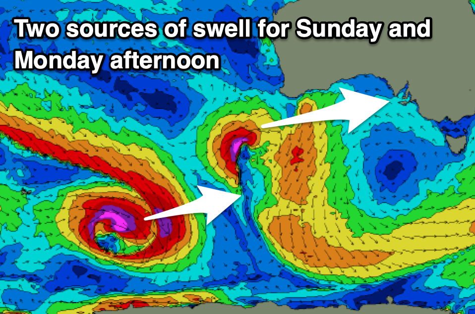
Now come Sunday, we’ve got a mix of W and W/SW groundswells due across the region, with the first and least consistent generated in our far swell window, through the Indian Ocean. This looks to provide inconsistent 2-3ft sets across Middleton later Sunday and Monday, with the Mid not expected to see much over 1-1.5ft.
A closer-range W’ly swell will perform better in the gulf, with a strong low due to form south-west of Western Australia tomorrow. A tight, short-lived fetch of W/SW gales should produce a pulse of swell for Sunday, kicking to 2ft across the Mid Coast, peaking overnight and easing from 1-2ft on Monday morning.
There’s also expected to be some additional SW groundswell Monday afternoon from a strong but short-lived polar low firing up just east of the Heard Island region tomorrow. The size looks to be in that 2-3ft range across Middleton, easing from a similar size Tuesday.
As touched on above, Sunday morning should be clean across both coasts, with the Mid remaining good into the afternoon, with Monday coming in great with a NE offshore down South, E/SE across the Mid ahead of sea breezes.
As the swells start easing Tuesday, the South Coast looks the pick under a N/NE offshore.
Longer term, there’s nothing major storm wise due through the Southern Ocean next week, resulting in a run of small surf with what looks to be SE to NE winds. More on this Friday.

