Slow improvement through the weekend
South Australian Surf Forecast by Craig Brokensha (issued Friday December 16th)
Best Days: Selected spots tomorrow mid/late morning South Coast, Sunday morning South Coast, swell magnets South Coast Monday morning
Features of the Forecast (tl;dr)
- New, moderate sized S/SW groundswell mixed with S/SE windswell Sat with gusty but easing E winds ahead of S/SE sea breezes
- Easing surf Sun with mod-fresh E/NE-NE tending SE winds
- Smaller Mon with fresh NE tending SE winds
- Small to tiny Tue with NE tending SE winds
Recap
The Mid Coast cleaned up and offered little 1ft+ runners for beginners yesterday, best on the incoming tide while the South Coast remained poor and onshore with a bit of size.
Today winds are around to the E and easing, creating improving conditions with a peaky 2-3ft of swell. The Mid is clean but only 0.5ft.

Little sets yesterday PM
This weekend and next week (Dec 19 - 23)
Looking at the surface conditions for tomorrow and it'll be similar to today with winds due to shift E'ly, poor early and still gusty, but easing through the morning ahead of S/SE sea breezes. There's a chance for E/NE winds at times through the morning and it'll become cleanest late morning just before the sea breezes kick in.

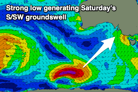
A new S/SW groundswell will arrive later today and peak tomorrow morning, generated by a strong, tight polar low earlier in the week. It'll be inconsistent but sets to 3ft to occasionally 4ft are due across Middleton, but with those E winds, Goolwa will be cleanest but a long paddle out.
The Mid looks to remain tiny to flat but nice and clean.
Easing surf is expected into Sunday and winds look to tip E/NE-NE during the morning, creating cleaner, peaky waves along with easing 2-3ft sets across the Middleton stretch.
From here on, into the middle of next week it'll be down, down, down. The blocking high linked to run of poor winds will deflect any major swell generating systems away from us, but it will start moving east through next week. This will swing winds more NE into Monday and Tuesday mornings but small to tiny leftovers out of the S/SE and SW.

The exposed beaches may offer slow 2ft sets but keep your expectations on the lower side of the coin.
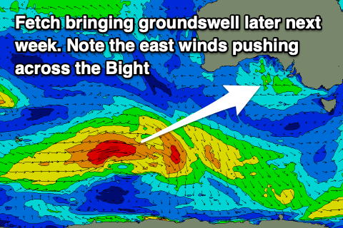
Later in the week some new, inconsistent SW groundswell is on the cards, generated by a distant but strong polar frontal progression east of the Heard Island region. This and a secondary pulse for the weekend unfortunately look to peak with S'ly winds as a trough pushes through Thursday evening, followed by a strong high. We'll have a closer look at this and what looks to be an increased in storm activity through the Southern Ocean on Monday. Have a great weekend!


Comments
Goanna have to find a different sport, or different country. No surf here for weeks.
Agree.