Fun weekend for both regions
South Australian Surf Forecast by Craig Brokensha (issued Friday October 7th)
Best Days: Both coasts tomorrow morning, Mid Coast later in the day as well, both coasts Sunday, South Coast magnets Monday, Mid Coast for beginners Monday, South Coast Wednesday
Features of the Forecast (tl;dr)
- Mix of new W/SW swells for Sat, biggest in the PM, easing Sun
- SE tending SW winds on the Mid, back to the S/SE late. Light W/NW tending SW down South
- New S/SW swell Sun, with an easing W/SW swell
- Light, local offshore winds ahead of weak sea breezes
- Easing surf Mon with moderate N/NE tending variable winds
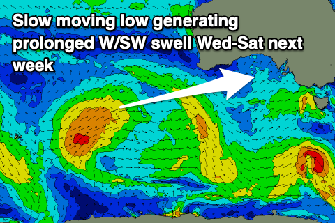
- Run of small-moderate sized W/SW swell from Wed through Sat
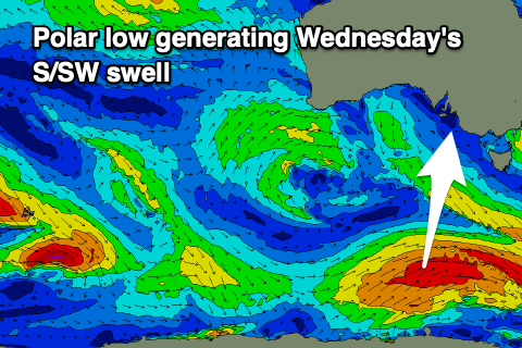
- Fun new S/SW swell Wed
- N/NW winds Wed, strengthening from the W on Thu, gusty but easing SW Fri
Recap
Great conditions down South but with a smaller 1-2ft of swell for the keen across the swell magnets. The Mid Coast was clean and glassy into the afternoon with a new pulse of W/SW swell to 1ft.
Today we've got a building mix of windswell and mid-period energy but with freshening onshore winds across the gulf, cleaner down South but tiny.

Glassy 1ft sets yesterday PM
This weekend and next week (Oct 8 - 14)
The broad and strong mid-latitude low linked to this week's strong E winds and rainfall is now weakening while slipping south-east, with us falling under the backside, bringing the increasing W'ly winds.
We should see this frontal wind starting to ease off into early tomorrow morning, leaving a moderate SW gradient wind across both regions, but local land breeze effects should steer S/SE-SE on the Mid Coast and W/NW around Victor before reverting back onshore late morning. On the Mid winds should tend back to the S/SE on dark.
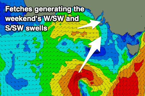
 Swell wise, our good pulses of mid-period W/SW swell energy are on track, while a SW swell due for the South Coast looks to have a slight downgrade, delay in timing and also more S/SW direction (not a bad thing).
Firstly the W/SW energy has been generated by back to back mid-latitude fronts pushing up and under Western Australia, generating fetches of strong W/SW winds.
We should see consistent 2ft sets through tomorrow and Sunday but 3ft sets due due into tomorrow afternoon and early Sunday as the strongest pulse of energy fills in from the front moving in towards the Bight yesterday.
The South Coast isn't due to see anything over 2-3ft, with the west nature of the swell, and the models are over-forecasting the size quite considerably.
A reinforcing pulse of mid-period S/SW swell is due Sunday, generated by a weak fetch of strong to gale-force S/SW winds in our southern swell window today. Sets to 2-3ft are due to continue across Middleton Sunday, easing Monday from 2ft.
Winds on Sunday look great for both regions with light local offshore winds, tending NW in the gulf through the afternoon and S/SE down South but without much strength.
 Moving into next week, another mid-latitude low forming to our west will be slow moving through the Bight, bringing persistent winds out of the northern quadrant before a change in wind and weather later next week.
N/NE winds are due on Monday morning with the small fading sets down South, 1-1.5ft on the Mid Coast, smaller Tuesday with gusty N/NE tending N winds.
Into Wednesday a new mid-period W/SW swell is due, generated by a relatively weak polar low that's currently south-west of Western Australia and will project a fetch of strong but weakening W/SW winds up through our western swell window on the weekend.
This is the same low that will meander in the Bight for most of the week, with additional fetches of W/SW winds due Monday through Thursday in our swell window.
 This will generate a prolonged episode of W/SW swell energy from Wednesday through next weekend.
Size wise it looks to 2ft through this whole period on the Mid, with the South Coast coming in around a similar size across Middleton. A slightly better S/SW swell should be in the mix Wednesday to 2-3ft though (generated by the middle image).
As touched on winds look to go N/NW on Wednesday and then stronger W tending SW Thursday/Friday as the low moves across us, creating poor conditions on the Mid Coast. The weekend might be more favourable and cleaner for a surf but check back here Monday for the latest. Have a great weekend!

