Average outlook compared to the recent run of surf
South Australian Surf Forecast by Craig Brokensha (issued Friday August 2nd)
Best Days: This afternoon Mid Coast, Mid Coast beginners tomorrow, keen surfers South Coast Sunday morning and the magnets Tuesday morning
Features of the Forecast (tl;dr)
- Easing SW swell tomorrow with moderate S/SE-SE winds, increasing from the S/SE
- Smaller Sun with E/NE tending fresh SE winds
- Small Mon with E tending E/SE winds
- Small S swell Tue with N/NE tending E/SE winds
- Inconsistent, small W/SW groundswell for Wed PM, easing Thu
- Fresh NE winds Wed, W/NW Thu
Recap
Great surf down South yesterday morning with clean conditions and 3-4ft sets across Middleton, best ahead of a SW change while the Mid Coast was a slow 1-2ft in the morning, pulsing to a good 2ft through the afternoon with the incoming tide but with a few bumps.
Today conditions are still average down South with a SE breeze, cleanest on the Mid with another pulse of SW groundswell maintaining 1-2ft sets. The incoming tide should again be the pick of the day with conditions remaining relatively clean along with consistent 2ft sets.

Good pulse in size yesterday PM
This weekend and next week (Sep 3 - 9)
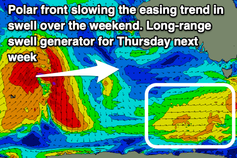
Today's final pulse of solid SW swell energy will ease slowly over the weekend, becoming tiny on the Mid Coast tomorrow while the South Coast will see some reinforcing mid-period S/SW energy slowing the dropping trend. This swell is being generated by a fetch of strong W/SW winds currently south-west of Tasmania.
Size wise, infrequent 1ft+ sets are due on the Mid Coast, ideal for beginners with the South Coast easing back from 4ft.
Winds will continue to be poor for the South Coast and moderate S/SE-SE in the morning, fresher S/SE into the afternoon while the Mid should stay clean all day.
 Better E/NE winds are due on Sunday morning down South but with onshore winds all day tomorrow the surf will be very lumpy and wobbly. Lower your expectations and expect sets to 3ft across Middleton, easing through the day along with SE sea breezes and then a smaller 2ft+ Monday.
Unfortunately a high moving in from the west will be semi-blocked by a low forming off the East Coast on the weekend, slowing its migration east and this will maintain E'ly winds on Monday morning, E/SE into the afternoon.
Tuesday finally should see a N/NE offshore but swell wise, a weak background S/SW swell looks to ease back from 1-2ft across Middleton. Try the swell magnets for the best waves.
Longer term, we've got an inconsistent W/SW groundswell due from a less than ideally structured low moving in from the Indian Ocean.
It'll be quite intense in nature, generating a great fetch of gale to severe-gale SW winds a little off angle to our swell window, but we should still see some fun waves generated for the Mid Coast on Wednesday afternoon and the magnets down South.
The swell should provide inconsistent 1-1.5ft sets Wednesday afternoon with gusty NE winds, 2ft across Middleton, with Thursday easing from a similar size under a W/NW breeze as a low pushes east across us.
Longer term there's nothing too much on the cards besides a weak W/SW swell late week from a mid-latitude low forming off Western Australia, but more on this Monday. Have a great weekend!


Comments
Conditions sound like what we would normally expect mid October and into November!!
Another rubbish outlook, worst Winter that I can remember in 40 years of surfing in SA.
Fuckety fuck.
Fukn La Nina and IOD, Mid latitude lows. I'm over em.
Be south east soon until next August.
Bring bank the drought.
Please someone build a wave pool here in Adelaide.
Absolutely