North-east winds with a strong but easing swell
South Australian Surf Forecast by Craig Brokensha (issued Monday July 18th)
Best Days: Mid Coast today, selected breaks tomorrow morning both coasts, South Coast Wednesday morning and Thursday, Saturday for the keen on the Mid, South Coast Sunday
Features of the Forecast (tl;dr)
- Large late pulse of S'ly groundswell this eve, peaking early tomorrow AM then easing
- Moderate E/NE tending E winds tomorrow
- Easing S/SW swell Wed with E/NE-NE winds and fresh E/SE-SE sea breezes
- Small, inconsistent S/SW groundswell Thu, fading Fri
- NE tending E/NE winds Thu, strengthening N/NE tending NE Fri
- Pulse of W swell Sat with N/NE tending N/NW winds
- Inconsistent small W/SW groundswell Sun with N/NE winds
Recap
Choppy 1-2ft surf across the Mid Coast on Saturday with increasing northerly winds, clean on the South Coast but tiny and nothing compared to pumping Friday. A new pulse of swell arrived for yesterday but with morning W/NW winds and 2-3ft sets across Middleton. Protected spots were best ahead of an onshore change while the Mid continued at a choppy 1-2ft.
Today we've got a solid mix of new mid-period S/SW swell and building groundswell later today down South with lighter winds and lumpy conditions. The Mid is a workable 1-2ft.
This week and weekend (Jul 19 - 24)
Looking at the current synoptic setup and we've got a strong polar outbreak pushing up and over Tasmania and Victoria, bringing with it an injection of cold air and snow to alpine regions.

We'll see a moderate-large S'ly groundswell arriving later today and peaking early tomorrow, originating from a fetch of S/SW gales through our southern swell window yesterday afternoon and evening as the polar front pushed north.
Easing sets from 4-6ft are due across Middleton and other exposed breaks and a strong high which will dominate most of this week will start moving slowly east. This will see winds shifting E/NE tomorrow morning, moderate in strength and likely holding from the E into the afternoon.
With the size of the swell and this wind combo, options will be limited and Wednesday looks much better with easing 3ft sets and an E/NE-NE breeze. Fresher E/SE-SE sea breezes are due into the afternoon, with Thursday seeing all day offshore NE tending E/NE winds but with small 2ft leftovers.
Coming back to the Mid Coast and we'll see the surf clean up tomorrow but fade from 1-1.5ft, tiny into Wednesday and near flat Thursday.
A small, poorly aligned polar front will generate a small S/SW groundswell for Thursday down South, providing those slow 2ft sets, easing Friday from 1-2ft.
We'll continue to see favourable winds though as the high stalls in the Tasman Sea and approaching fronts squeeze its north-western flank, bringing stronger N/NE tending NE winds Friday, N/NE tending N/NW on Saturday as the front slides south-east.
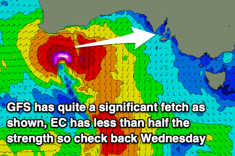
 A low point in swell is expected on Saturday morning down South, but on the Mid Coast a new pulse of W'ly groundswell is expected.
The source of this will be the front moving in from the west, dipping south-east with a great but tight fetch of W/SW winds due to be projected under Western Australia Thursday evening.
The models don't align regarding its strength at the moment with the outcome being surf between 1-3ft. You'll have to check back here on Wednesday for the latest but we should see at least 2ft sets and with bumpy but workable conditions. Owing to the west in the direction the South Coast will remain small to tiny.
Otherwise, a very long-range and inconsistent SW groundswell signal may be seen Sunday, with 2ft sets across Middleton but with a very long wait. The source of this swell was the same that generated the pumping final days at J-Bay, generated south-west of South Africa. There might be the rare bigger 3ft set for the super patient and winds will remain offshore from the N/NE.
Longer term we'll likely see a stronger frontal progression developing into the end of the month, bringing larger, onshore surf. More on this and Saturday's swell on Wednesday.

