Windows of clean conditions between changes
South Australian Surf Forecast by Craig Brokensha (issued Wednesday Jul 6th)
Best Days: Today South Coast, tomorrow for the keen Mid Coast, Sunday South Coast, next Thursday both coasts
Features of the Forecast (tl;dr)
- Easing S/SW swell tomorrow with fresh S/SW winds down South, light offshore tending S on the Mid
- Tiny W'ly swell for the Mid Coast tomorrow, peaking in the PM
- Small to tiny surf Fri with fresh S/SW winds (S/SE early on the Mid)
- Inconsistent, small mid-period SW swell for Sat and Sun AM, easing into the PM and fading Mon
- Small S'ly windswell for Sat
- Moderate S tending S/SE winds Sat, N'ly Sun
- Strong N tending NW winds Mon
- Moderate + sized W/SW swell for Tue/Wed with gusty W/SW-SW winds on Tue, S/SW Wed
- Easing surf Thu with local offshore winds
Recap
An improvement in conditions across the South Coast yesterday morning under E/NE winds. It wasn't great but there were clean faces and lumpy 2-3ft offerings towards Goolwa. The Mid Coast offered a tiny 1ft+ tease of swell ideal for bigger boards and beginners.
This morning the South Coast is much cleaner and super fun with 2ft waves across Middleton and more size on the magnets. The Mid is back to a tiny 0.5-1ft and only suitable for beginners.

Nice and clean down South today
This week and weekend (Jul 7 - 10)
Currently a weakening frontal system (come trough) is moving in from the west and this will bring a shallow S/SW change this evening which will strengthen into tomorrow across the state as a high tries to push in behind it. This will bring poor, fresh S/SW winds to the South Coast but better, variable offshore winds on the Mid Coast, increasing from the S'th into the afternoon. Therefore make the most of today's conditions down South.
Swell wise the South Coast will fade back from 1-2ft while the Mid Coast should see a small, weak W'ly swell filling in through the day, reaching 1-1.5ft. This was generated by the earlier stages of the front and will only be for the keen.
Poor S/SW winds will hold into Friday (S/SE early on the Mid Coast) but with a tiny, fading W/SW swell from 1ft while there'll be some weak S'ly windswell on the South Coast to 2ft to possibly 3ft.
 Troughy activity to our east will prevent the high pushing in quicker through the weekend, with easing S tending S/SE winds due on Saturday, much better Sunday with N tending variable winds ahead of the next approaching frontal activity.
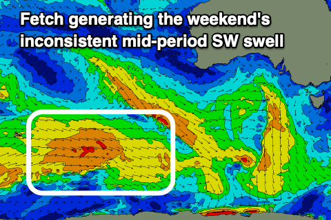
As touched on in Monday's notes, there should be some inconsistent, mid-period SW swell energy on the South Coast, generated by a healthy but not overly strong polar frontal progressed that's taken place south-west of Western Australia.
Infrequent 2ft to occasionally 3ft sets are expected on Saturday and Sunday morning before easing into the afternoon and then down from a small 1-2ft on Monday. Stronger N tending NW winds will create tricky conditions with the fading swell Monday, so it's not looking great.
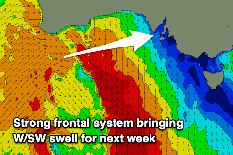
 The frontal activity moving in and under Western Australia through Sunday and early next week will produce a fun pulse of mid-period W'ly swell for the Mid Coast for Tuesday and Wednesday. Winds look average as a low forms in the weakening front and trough line, bringing gusty W/SW-SW winds on Tuesday, swinging S/SW on Wednesday and then cleaner Thursday as the swell eases.
The Mid Coast should see surf to 2-3ft, easing from 1-2ft on Thursday. More on this Friday though.


Comments
Cliffs had some nice clean waves this morning and about 3' on the sets, probably around the time the pic was taken. It was likely pretty solid out west early!
Nice, yeah watching the cam early it looked a really peaky 2-3ft.
Yiu wouldn't by any chance have jbay forecast?
Tomorrow.
Yep the banks at Waits weren't really holding the sets with the early low tide.
I ended up surfing the Cliffs as well.