Poor weekend, large and windy Monday
South Australian Surf Forecast by Craig Brokensha (issued Friday November 12th)
Best Days: Protected spots early Monday South Coast, Tuesday morning South Coast, keen beginners on the Mid Coast Tuesday morning, Wednesday morning South Coast
Features of the Forecast (tl;dr)
- Small mix of swells Sat with strong S/SW tending SW winds
- Building SW windswell Sun with early, strong W tending W/SW-SW winds
- Large, mid-period S/SW swell Mon with fresh to strong SW winds (possibly W'ly early in Victor)
- Easing S/SW swell Tue with variable morning winds (light S'ly down South) and afternoon S/SE sea breezes
- Fading S/SW swell Wed and Thu with morning N/NE winds
Recap
Conditions were a little better than expected yesterday morning on the South Coast with E'ly winds and a peaky mix of swells to 2-3ft, but the afternoon deteriorated with a strengthening S'ly wind and choppy conditions.
Today is a full blown slopfest with strong S'ly winds and 3ft of windswell. The Mid was tiny and clean yesterday with a tiny increase in local windswell today but only suited to beginners.
This weekend and next week (Nov 13 - 19)
We've got a few more days of poor conditions and winds ahead of improving conditions from Tuesday.
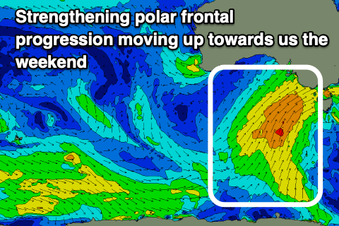
We'll see winds swing back to the S/SW and then SW (strong) tomorrow as a strengthening polar frontal progression pushes up and into us from the south. This will create poor conditions across all locations with a mix of windswell and weak, mid-period swell.
 Just ahead of the front pushing through Sunday winds will tip W'ly around dawn Sunday morning, though strong in nature, but swinging W/SW-SW by mid-morning and remaining so the rest of the day. There'll be no swell with size or power early in any case.
As the front moves through Sunday we'll see a localised increase in windswell across both coasts, reaching 2-3ft on the Mid Coast and building down South from a small 2ft early to 3-4ft later in the day across Middleton.
A larger, mid-period S/SW swell will be seen Monday from the frontal progression proper, with a broad fetch of strong S/SW winds projected up and into us during the weekend.
While not reaching gale-force, the projection and slow moving nature of the swell generating fetch will produce large, consistent surf, peaking through Monday to an easy 6ft across Middleton with the deep water reefs similar in size, if not for the odd bigger one. Unfortunately conditions will be poor with persistent strong SW winds, though we may see more favourable W'ly winds early around Victor if we're lucky.
The Mid Coast will remain onshore and choppy with easing surf from 2ft+ or so.
A high will start to move in Tuesday and this should bring variable winds which may still be just lingering out of the S'th. While not ideal the South Coast should be fun and improving through the morning ahead of S/SE sea breezes.
Size wise the swell will be easing from a chunky 4ft+ out of the S/SW, tiny on the Mid but clean and ideal for beginners.
Wednesday is the pick with a N/NE offshore and easing 2-3ft sets across Middleton. Make the most of this window as the swell will bottom out into Thursday but with similar, favourable N/NE winds.
Longer term there's nothing too significant on the cards with small swells and average S/SE winds due into next weekend as a trough pushes through. More on this Monday though. Have a great weekend!


Comments
Poovember
Ha, and the colour of Middleton now.
I read somewhere recently that we are heading for another La Nina summer which will likely mean below average conditions again for SA. Craig, would you have any update on this?
Yeah I've been discussing it on the site for the past few months. Here ya go: https://www.swellnet.com/news/swellnet-analysis/2021/10/12/double-dippin...