Hit the beaches over the coming days
South Australian Surf Forecast by Craig Brokensha (issued Monday February 15th)
Best Days: Keen surfers Friday, beaches Saturday morning, keen surfers Tuesday and Wednesday mornings
Features of the Forecast (tl;dr)
- Easing SW groundswell tomorrow with variable NE winds ahead of relatively weak sea breezes
- Reinforcing mid-period SW swell Wed with N/NE tending E/NE winds in the AM ahead of sea breezes, easing Thu with similar winds (holding E/NE until late), small Fri with strong NE tending weaker N/NW winds
- Inconsistent W/SW groundswell building late Fri, peaking Sat with S/SE tending S/SW winds
- Strong W/SW groundswell Mon with S/SE tending S/SW winds
Recap
Friday's kick in new W/SW swell came in nicely across the Mid Coast with 2ft+ sets, though bumpy conditions. The swell eased back into Saturday with lumpy, workable 1-2ft waves, while a reinforcing swell Sunday maintained 1-1.5ft+ surf.
The South Coast was on the small side and onshore all weekend. Late yesterday a new SW groundswell arrived and this has provided a bit more size and energy this morning with an improvement in the local winds as well.
This week and weekend (Feb 16 - 21)
The coming three days are looking worth a surf on the South Coast with favourable winds and fun pulses of swell that won't be too big for the exposed beaches but offer plenty of fun options from Middleton to Goolwa as well.
This morning's SW groundswell is due to ease this afternoon, dropping back to a smaller 2ft across Middleton, tiny on the Mid Coast. Winds look variable, possibly tending NE ahead of sea breezes which look to kick in early afternoon but without too much strength.
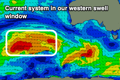
Later in the day and more so Wednesday, a new mid-period SW swell is due to fill in, generated by some healthy, elongated polar frontal activity moving in through our swell window late last week and on the weekend.
The swell should peak Wednesday morning with 2-3ft sets across Middleton, remaining tiny and to 1ft or so on the Mid Coast. Conditions will be favourable with a N/NE morning offshore, shifting E/NE late morning ahead of E/SE sea breezes.
Thursday will see the swell easing from 2ft at Middleton along with similar winds, though fresher, and sea breezes may be suppressed into the afternoon.
Come Friday the swell will bottom out with 1-2ft leftovers across Middleton, and winds will strengthen from the NE, easing and tending N/NW into the afternoon ahead of a late change.
 Now, looking at the W/SW groundswell due late week, and the size is now due Saturday, though it'll be inconsistent and a much better swell is due early next week.
The source of this first swell is a strong frontal progression that's currently positioned north-east of the Heard Island region, generating gale to severe-gale W/NW-W/SW winds, but in our far western swell window.
This isn't ideal for consistency or size, but we should still some fun waves on the Mid Coast, with a possible tiny increase Friday afternoon to 1-1.5ft, though peaking Saturday to 2ft. Winds aren't ideal but workable and should be out of the S/SE early Saturday, shifting S/SW thereafter, with S/SE-SE winds Sunday morning but tiny surf.
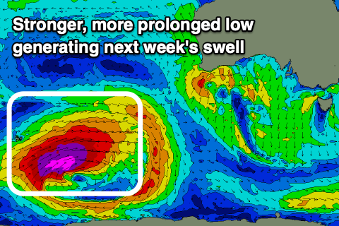
 Looking at the better W/SW groundswell due early next week, this will be produced by an initially distant and very intense polar low that'll form around the Heard Island region tomorrow, projecting closer towards us through the week while weakening.
The initial fetch will see severe-gale to storm-force W/SW winds generated, projecting east-northeast while weakening just a touch. The storm is then expected to continue weakening under the country while tracking east-southeast, with the swell due to fill in overnight Sunday, peaking Monday.
This looks like a good 2-3ft on the Mid Coast, if not for the odd sneaky bigger one on the magnets and with a S/SE tending S/SW breeze as a cold front spawning off the progression clips the state. Tuesday looks a touch better with a longer lived S/SE breeze, but more on this Wednesday.

