Mixed weekend, much better next week
South Australia Surf Forecast by Craig Brokensha (issued Friday 11th September)
Best Days: Thursday
Recap
After Wednesday’s pumping waves on the Mid Coast, yesterday dropped back to a less consistent 1-2ft while the South Coast was lumpy and peaky, improving across the breaks that like the NE wind through the day.
Today we’ve got a low point in swell this morning along with great conditions down South, tiny and wind affected on the Mid Coast. A new inconsistent W/SW groundswell is due this afternoon and this should provide 1-2ft sets, though conditions will remain wind affected.
This weekend and next week (Sep 12 - 18)
This afternoon’s increase in W/SW groundswell will drop through tomorrow leaving tiny waves on the Mid Coast to an inconsistent 1-1.5ft, while the Middleton stretch also looks to remain small to tiny (1-2ft).
A shallow change this evening should become more variable tomorrow morning, cleanest on the Mid Coast while the South Coast looks lumpy with a light morning E/NE breeze.
Through the afternoon tomorrow, a new inconsistent W/SW groundswell is due, building ahead of a peak Sunday morning. This swell was generated in our distant western swell window and will favour the Mid over the South Coast.
Inconsistent sets to 1-2ft are possible later Saturday but Sunday should offer infrequent 2ft sets aross the Mid Coast swell magnets along with an increase to 2-3ft across Middleton.
Winds look best for the Mid still as a high moves in slowly from the west, bringing early S/SE winds, shifting S/SW-SW into the afternoon and freshening, onshore all day down South.
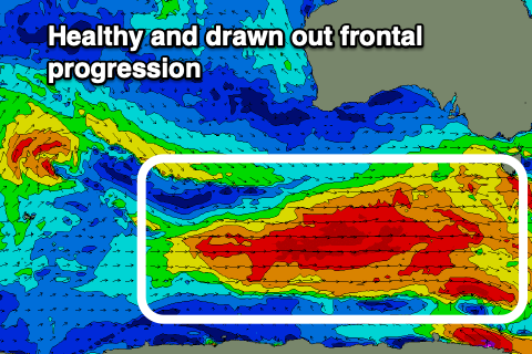
 Moving into next week and our conveyer belt of frontal activity pushing in from the Heard Island region is on track, and there’s no real standout system, just a healthy and prolonged fetch of gale to severe-gale westerly winds moving through our swell window.
The progression is currently in our far swell window but will move in closer to us through the weekend, with a good fetch of severe-gale W/NW winds developing south-west of WA this afternoon and evening. This will then move under the country tomorrow afternoon and evening, shifting more W/SW in direction, followed by a trailing fetch of broadening W/SW severe-gales south-west and then south of us Sunday and Monday.
An initial pulse of SW groundswell is due Monday, with a secondary pulse for Tuesday, then easing through the end of the week.
These swells will favour the South Coast over the Mid and we should see Middleton building from 3ft+ or so, reaching 4-5ft into the afternoon, holding Tuesday. The Mid Coast looks to see very inconsistent 1-2ft sets from Monday afternoon through Tuesday, 1-1.5ft on Wednesday.
Now, winds on Monday are a little dicey as a weak trough moves through bringing a shallow S/SW change around dawn, but with the quality of the swell the waves will still be fun.
Tuesday looks great with local, light offshore winds ahead of sea breezes, N’ly all day Wednesday as the swell slowly eases, similar Thursday.
Longer term there’s nothing too significant until the following week, but more on this Monday. Have a great weekend!


Comments
Still a few fun small peelers on the Mid this morning.
