Easing swell with northerly breezes, very large west swell likely late next week
South Australian Surf Forecast by Craig Brokensha (issued Friday 26th June)
Best Days: Both coasts tomorrow (cleanest down South), South Coast Sunday, South Coast Wednesday and Thursday, Mid Coast Friday
Recap
Tiny and clean waves yesterday only suitable across the swell magnets down South for the desperate, much different today with a fun new W/SW swell and local offshore winds. Middleton is seeing clean and good 3ft waves, with 2ft+ surf on the Mid Coast. We’ll see the swell peaking to an easy 2-3ft on the Mid Coast this afternoon with the help of the tide and holding down South as winds remain favourable.
This weekend and next week (June 27 – Jul 3)
Today’s W/SW swell is expected to start easing tomorrow, but the morning should still see 3ft sets off Middleton, 2ft on the Mid Coast along with N/NE tending variable winds on the South Coast and NE tending N winds in the gulf, easing later.
Sunday will become tiny on the Mid, while the South Coast will ease from a small 2ft along the Middleton stretch with N’ly tending variable winds again.
Monday and Tuesday look like lay days as the swell bottoms out along with increasing N/NE winds on the former, stronger out of the N/NW on the latter as a series of strong mid-latitude fronts start edging in from the west.
This incoming frontal activity will be linked to a strong node of the Long Wave Trough that’s sitting over WA, pushing slowly east, bringing a flurry of significant mid-latitude frontal activity through our western swell window.
The first of the swell generating mid-latitude systems will drop east-southeast into the Bight from across WA on Monday, with a tight fetch of strong to gale-force W/SW winds expected to project east through our swell window, crossing us later Tuesday.
This will bring a spike of small to moderate sized and acute W’ly swell Wednesday to 2-3ft on the Mid Coast, while the South Coast isn’t due to see too much size owing to the westerly angle. Middleton will only likely offer slow 2ft sets.
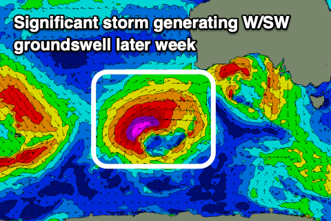
 Of greater significance is a very strong polar low that’s forecast to develop east of the Heard Island region and project east-northeast up through the Bight through next week.
A significant fetch of severe-gale to storm-force W/SW winds will be generated as it tracks east-northeast but from here the models diverge with EC showing the progression continuing into us but with less strength while GFS pushes it north and inland.
Either way we’re due to see a very large, long-period W/SW groundswell, building Thursday afternoon and holding Friday morning with a peak in the 4ft range on the Mid Coast and 4-6ft off Middleton.
Coming back to the local winds and a strong N/NE tending NW breeze will spoil the first swell Wednesday, with less favourable and strong W/NW winds Thursday, SW on Friday depending on the timing of the low pushing east across is. With the slight divergence check back here on Monday for the latest forecast regarding the size, timing and local winds. Have a great weekend!


Comments
Nice small lines on the Mid this morning, a little inco but old mate jammed a decent cutty in the second frame.

