Good surfing options all period
South Australian Forecast by Craig Brokensha (issued Monday 15th June)
Best Days: South Coast tomorrow, both coasts Wednesday, South Coast Thursday, Friday and Saturday, Mid Coast Sunday
Recap
Tiny waves on the South Coast with generally clean conditions but limited options for anything of substance, building on the Mid Coast and reaching a choppy 2ft yesterday.
Today the Mid is a choppy 2-3ft with the arrival of a new W/SW groundswell, propping the South Coast also up to 4ft or so, cleanest in protected spots.
This week and weekend (Jun 16 - 21)
Coming in off a cold start it's tricky to pick up on an active episode of W/SW groundswell. Ben's pegged an increase in new W/SW groundswell to 4-6ft by this afternoon across the Middleton stretch and the Cape du Couedic wave buoy is looking healthy with plenty of size and a good kick in period as well. The Mid Coast should continue around 3ft, but the gusty W/NW-NW winds are favouring protected locations on the South Coast.
 It looks like we'll fall slightly between swells tomorrow ahead of what looks to be the best increase in size on Wednesday.
The drawn out frontal progression linked to this week's run of swell has weakened temporarily and this should result in the size dropping back a touch to 4-5ft tomorrow across Middleton and to 3ft on the sets across the Mid Coast on the favourable parts of the tide.
Winds will remain favourable for protected locations down South and average for the Mid with a moderate to fresh W/NW-NW tending W/NW wind.
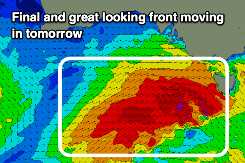
A secondary large increase in SW groundswell for Wednesday is being generated today by a trailing embedded front on the tail of the progression, strengthening south of the Bight. A great fetch of gale to severe-gale W/SW winds will move on top an active sea state and through our western and then south-western swell windows this evening and tomorrow as it pushes towards and then across Tasmania.
The SW groundswell should provide a boost back to 4-6ft across the Middleton stretch Wednesday morning, easing later in the day while keeping the Mid Coast around 3ft on the sets working the favourable parts of the tide.
A late drop in swell will ease further Thursday from 4ft off Middleton and 2-3ft on the Mid Coast, smaller Friday.
Conditions are looking great for both regions Wednesday as a high moves in resulting in NE offshores on the Mid, light N/NW down South and becoming variable through the afternoon. This looks the pick of the week for the state.
Gusty N/NE winds on Thursday will favour the South Coast as the swell eases, similar Friday before tending more N/NW into the afternoon as a mid-latitude low moves in slowly from the west.
Now, this low won't be overly strong or well positioned to generate swell for our region but the earlier stages which has formed north-east of the Heard Island region will generate an inconsistent W'ly groundswell for Saturday afternoon.
A distant fetch of off-angle W'ly gales will move slowly through our swell window and while not the best source, we should see inconsistent 2ft waves developing through Saturday on the Mid Coast, 2-3ft off Middleton, with some mid-period W/SW swell energy for Sunday from the low proper. Size wise it looks to be a weak 2ft or so, and 2-3ft again off Middleton.
Winds are a little tricky depending on where the low positions itself but likely NW on Saturday and S/SE Saturday as the low moves east, though check back here on Wednesday for a much clearer idea regarding this and the localised swell.


Comments
The Bay's pumping on the cam. Woo!
Indeed you are correct - two images from one wave (below).


Pretty sure i picked a couple of familiar styles burying some rails through the inside too.
Nice lines on the Mid this AM.
