Good waves to start the weekend, average until winds improve towards mid- next week
South Australian Forecast by Craig Brokensha (issued Friday 21st September)
Best Days: South Coast Saturday morning, and then Tuesday and Wednesday
Recap
Good fun waves across the South Coast yesterday morning with plenty of size leftover from Wednesday and good winds for protected locations. An afternoon onshore didn't do too much damage either. The Mid Coast was bumpy in the morning and around 1-2ft, cleaner into the afternoon as the onshore breeze backed off.
This morning we've got a low point in swell across both coasts with tiny Mid Coast waves and small 2ft leftovers off Middleton but with nice clean conditions.
Our strong new long-period S/SW groundswell is on track with it hitting Cape Sorell at dawn this morning and showing a strong distinct J-curve (below), which is rarely seen across the Southern Ocean buoys. The swell is south so will take a bit longer to reach us but should kick mid-late afternoon and reach 3ft to possibly 4ft off Middleton with variable sea breezes.


Today’s Forecaster Notes are brought to you by Rip Curl
This week and weekend (Sep 22 – 28)
This afternoon's late pulse in strong long-period S/SW groundswell is due to peak overnight and ease back steadily through tomorrow, from 3ft+ down to 2ft+ or so into the afternoon. The Mid Coast will remain tiny with the poor southerly direction.
The models are over-forecasting the expected size across our region for Middleton, so ignore the numbers and follow the trends.
Winds will be great through the morning with a light N/NW offshore, though a shallow SW change is due into the afternoon, so surf before lunch.
This change will be linked to a surface trough sliding in from the west and then strong high behind it, bringing SE tending S/SE winds into Sunday.
A new SW groundswell is due to build but conditions will be average with these winds, cleaner on the Mid with tiny beginner waves into the afternoon to 1ft.
The groundswell will be generated by a broad and relatively strong fetch of W/SW winds projecting towards Victoria today and tomorrow, with a secondary burst on its tail generating a touch more south in the swell for Monday.
Size wise, we should see building surf Sunday afternoon, likely reaching 3ft to possibly 4ft on dark across Middleton and 1ft on the Mid Coast with those S/SE winds, peaking Monday to a more consistent 3-4ft.
 Winds will improve slightly on Monday but conditions will likely still be peaky from the weekend's onshores with a morning E/NE breeze, tending S/SE through the day.
Tuesday is looking much better as winds swing NE-N/NE with fun easing sets from the 3ft range off Middleton, tiny on the Mid Coast.
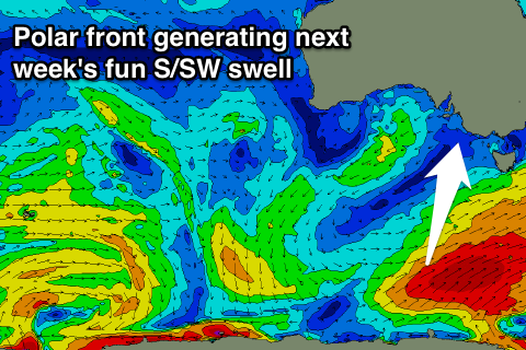
The easing trend will be slowed slightly by a fun sized S/SW groundswell filling in Wednesday, generated by a late forming polar frontal system in our southern swell window.
The front won't be well aligned but we should see a broad fetch of strong to gale-force W/SW winds forming late in our southern swell window, south-west of Tassie.
Winds look great and out of the N/NE, with a possible mid-late afternoon W/SW change as a weak mid-latitude low moves east. Middleton is expected to come in at a fun 2-3ft, with a bit more size at Waits and Parsons, and then from here the outlook goes quiet, with nothing of real significance to follow. Therefore make the most of the coming good windows of swell and conditions. Have a great weekend!


Comments
Hi Craig - you prefer using Cape Sorell to Cape Du Coeudic when forecasting south oz?
Craig's just logged off (so I'll answer) - but I suspect he used Sorell as an example, as there was no data showing at CdC at the time his notes were prepared (though it's now picking up leading edge of 18 seconds).
Cheers Ben
Sorry Maddog, missed this Friday.
Normal everyday swells Cape du Couedic for surf, but when looking for swells from the south it's good to keep an eye on Cape Sorell.
Crazy double up wedge this AM.
