Upgrade in S/SW swell due late week with east winds next week
South Australian Forecast by Craig Brokensha (issued Wednesday 19th September)
Best Days: Protected spots early tomorrow South Coast, South Coast Friday and Saturday morning, South Coast keen surfers Monday and Tuesday morning
Recap
Signs of new swell yesterday morning across both coasts with bumpy 2ft waves on the Mid and 3ft surf off Middleton, but into the afternoon the large long-period W/SW groundswell really muscled in.
Conditions were poor on the Mid Coast with a strong onshore wind and messy 3ft surf, while the South Coast saw good waves in protected spots with the strong W'ly.
This morning the swell was still solid across both locations, but best down South and in protected spots with a W/NW breeze. Winds have since swung onshore down South, creating average conditions.
Today’s Forecaster Notes are brought to you by Rip Curl
This week and weekend (Sep 20 – 23)
Our current W/SW groundswell is expected to ease back over the coming days, with the S/SW groundswell due later Friday being upgraded in size along with the arrival time being brought forward.
But looking at tomorrow and Middleton should still be offering sets in the 3ft+ range before easing to a small 2ft Friday morning. The Mid Coast looks to ease back from 2ft tomorrow morning, small to tiny and to 1-1.5ft on the favourable parts of the tide Friday.
 Winds will weaker across both coasts and generally moderate to sometimes fresh out of the W/SW, with Victor likely to see an early W/NW breeze.
Friday will be much cleaner with a N/NW offshore expected to persist most of the day (N/NE early on the Mid Coast), likely variable into the afternoon as a new long-period S/SW groundswell fills in.
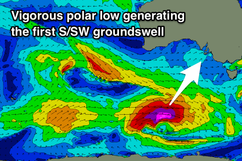
This swell will be generated by a deepening polar low forming south of WA today, with a fetch of severe-gale to storm-force W'ly winds being projected east, through our southern swell window for around 24 hours.
A moderate sized long-period S/SW groundswell should result, arriving through Friday afternoon and building 3ft to possibly 4ft off Middleton by dark, peaking overnight and easing from the 3ft+ range Saturday morning.
With the southerly direction, the swell won't really impact the Mid Coast with tiny surf due.
Conditions will be great again Saturday morning with a NNW offshore, shifting W/NW later morning ahead of a shallow afternoon S/SW change as a surface trough moves through.
A strong high will then move in behind the trough, but stall south of the Bight as a deepening surface trough come mid-latitude low forms off southern WA.
This will result in persistent winds from the eastern quadrant from Sunday through most of next week as good pulses of S/SW groundswell fill in.
Sunday looks poor with SE winds and a building S/SW groundswell that's due to peak Monday, generated by a strengthening polar frontal progression moving through our western and then south-western then southern swell window later this week and on the weekend.
Middleton may reach 3ft by dark, with a peak Monday to 3-4ft, while the Mid Coast should see a tiny increase in size Sunday afternoon to 1ft, persisting Monday at a similar size.
Winds will improve and tend more E/NE on Monday morning morning, NE Tuesday as the mid-latitude low starts moving in from the west, but more on this Friday.
Into the middle of next week a final pulse of S/SW groundswell from a strong polar front firing up south-west of Tassie is due as winds persist from the E-NE, but we'll have a closer look at this next update.

