Good waves tomorrow, mixed over the weekend
South Australian Forecast by Craig Brokensha (issued Wednesday 8th August)
Best Days: Both coasts tomorrow (Mid Coast early), South Coast Saturday morning and Monday
Recap
Poor onshore surf hanging in around 2-3ft on the Mid Coast yesterday and today, while the South Coast saw improving conditions yesterday as morning W/NW winds shifted more NW with fun amounts of swell.
This morning was best early with some OK swell but with no real strength, and winds quickly shifted back onshore.
Today’s Forecaster Notes are brought to you by Rip Curl
This week and weekend (Aug 9 - 12)
Want to receive an email when these Forecaster Notes are updated? Then log in here and update your preferences.
Tomorrow morning is still looking the best of the week for a surf down the South Coast, with a mix of building mid-period and longer-period swell due to peak, generated by the mid-latitude front that pushed across us this morning.
The swell is quite west in direction but should provide good fun waves to 3ft off Middleton with more strength than today, while the Mid Coast looks to ease from 2-3ft.
Winds will be great all day across the South Coast, moderate from the N'th early and strengthening from the N/NW into the afternoon, while the Mid Coast should see a window of OK conditions with an early N/NE breeze.
Friday is looking a bit average with strong to near gale-force N/NW winds early and a low point in swell, likely blown out down South, while the Mid Coast will be small and choppy.
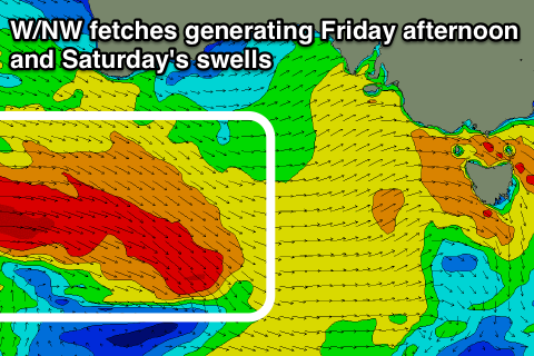
 We've got some new W/SW groundswell due into the afternoon ahead of a better pulse on Saturday, generated by a good pre-frontal fetch of W/NW gales that are currently south of WA. This fetch and a slightly stronger trailing fetch should generate some new inconsistent W/SW groundswell for Friday afternoon, building to 3ft off Middleton later in the day and holding a similar size through Saturday.
The Mid Coast looks to be smaller and to 1-2ft, similar Saturday but some localised W/SW swell will fill in over the top to 2-3ft later in the day from a relatively weak cold font pushing across us.
With the weak front passing across us we'll see winds swing W/SW Friday afternoon, W/NW for a period through Saturday morning before slipping W/SW again late morning.
On the backside of the weak front pushing across us Saturday we'll see a polar fetch of SW winds projecting up slowly towards us, bringing with it an increase in mid-period SW swell for Sunday afternoon and Monday morning.
It won't be especially strong and winds will be mostly onshore out of the SW on Sunday, but Monday looks fun with NW offshores as the swell eases.
Longer term we've got a much more significant storm on the cards for early next week, developing south-west of WA and projecting a fetch of severe-gale to storm-force W/SW winds towards us.
A large W/SW groundswell is on the cards for mid-late week, but more on this Friday.


Comments
Seems like groundhog day at the moment. Day after day of westerlies with a window of winds from the north every few days. The mid is getting hammered by it all which is a shame with the pretty consistent swell coming through.