Strong winds to end the week, upgrade in swell for the weekend
South Australian Forecast by Craig Brokensha (issued Wednesday 1st August)
Best Days: Dawn South Coast tomorrow, keen surfers South Coast Saturday, South Coast Sunday and Tuesday
Recap
Fun waves across the South Coast yesterday morning with a drop in swell from Monday with favourable winds before strengthening from the W/NW into the afternoon, The Mid Coast was small and choppy, with a building NW windswell through the afternoon.
Today we've seen a strong and powerful W/SW groundswell fill in, mixed with some mid-period energy with straight 3ft+ sets on the Mid Coast, a touch bumpy but good with a variable tending moderate N'ly breeze.

Middleton was also solid with 4ft sets breaking way off the Bay along with favourable offshore winds. We should see the swell hold all day as winds remain favourable.
Today’s Forecaster Notes are brought to you by Rip Curl
This week and weekend (Aug 2 - 5)
Want to receive an email when these Forecaster Notes are updated? Then log in here and update your preferences.
Today's mix of strong W/SW swells will ease back through tomorrow under strong and possibly near gale-force N/NE offshore winds. This will create very tricky and blustery conditions which won't be great for surfing with winds due to ease off slightly mid-afternoon before swinging more N/NW.
With this in mind the dawny is probably the pick before winds get too strong along with rapidly easing sets from the 3ft range off Middleton, down to 1-2ft into the afternoon.
The Mid Coast looks to ease back to 2ft tomorrow morning, with a possibly late increase in N/NW windswell.
A westerly change is due overnight and with this a small increase in windswell to 1-2ft is due on the Mid Coast through the day along with gusty and varying W/NW tending W/SW winds, back to the W/NW through the afternoon. The South Coast will bottom out and remain small to tiny and average, with some possible small inconsistent W/SW groundswell later in the day to 2ft off Middleton, though not worth a trip from out of town.
Looking at the weekend and we've had an upgrade in the W/SW groundswell due on Sunday, but ahead of this on Saturday some small and inconsistent new W/SW groundswell will fill in.
Saturday's swell was generated by a distant though strong storm in the southern Indian Ocean over the last few days, with very inconsistent sets due off Middleton to 2ft+, more so around 3ft on the sets off Day St and Cliffs.
 The Mid Coast looks to continue around the 2ft range, with a building NW windswell to a similar size through the day under strengthening N/NW-NW winds.
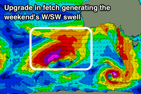
Moving into Sunday, our new pulses of better W/SW groundswell from a pre-frontal and post-frontal fetch around a strong low have been upgraded fairly significantly.
This low is now expected to be much stronger and longer-lived, with the initial pre-frontal fetch of severe-gale W/NW winds setting up an active sea state for a storm-force fetch of W/SW gales to move over, projecting slowly through our western swell window for 24 hours, before stalling south of WA and weakening a touch.
We'll continue to see a fetch of severe-gale W/SW winds aimed through our swell window, projecting through the Bight on Saturday and across us during Sunday in a much weaker form.
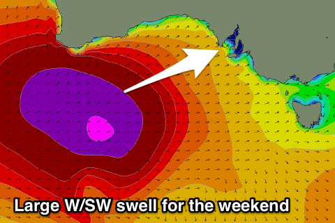
 A large and powerful long-period W/SW groundswell will be generated with it due to fill in Sunday and peak into the afternoon, though remaining large Monday due to the slow moving nature of the low.
We should see the Mid Coast building to a strong 3-4ft through the day while Middleton is expected to reach 4-6ft under fresh and persistent W/NW winds.
Monday looks to come in a touch under and more so 3ft on the Mid Coast with 4-5ft sets off Middleton down South with less favourable W/SW breezes. A slow drop in size is expected through the rest of the week as winds swing back towards the north-west with passing fronts, but more on this Friday.

