Fun southerly swells and favourable conditions
South Australian Forecast by Craig Brokensha (issued Monday 21st May)
Best Days: Every morning on the South Coast, all day Friday and Saturday, Sunday morning
Recap
Variable winds and clean though slightly lumpy waves dropping from the 3ft range off Middleton Saturday, smaller Sunday morning with less than ideal winds. The Mid Coast was tiny all weekend with lumpy conditions Saturday and choppy waves Sunday.
Today a new S/SW groundswell has provided good clean 3-4ft waves down South with early favourable winds, tiny and choppy on the Mid Coast.
Today’s Forecaster Notes are brought to you by Rip Curl
This week and weekend (May 22 – 27)
We've got multiple strong S/SW groundswells on the way this week and into the weekend owing to a strong node of the Long Wave Trough sitting over the Tasman Sea.
This is directing polar storms from below the country up towards Tasmania, with each system forming late in our swell window, but generating great fetches.
Currently a strengthening polar front is generating a fetch of polar W/SW gales and will project towards Tasmania while strengthening, producing a fun S/SW groundswell for Wednesday morning.
 Tomorrow we shouldn't really see the swell dropping below 3ft off Middleton, tiny on the Mid Coast, along with early W'ly tending W/SW-SW winds.
Our models are incorrectly combining swells Wednesday morning but Middleton should come in at a good 3-4ft with an early W/NW breeze, swinging back SW through the day.
Thursday will see the swell dropping back with a light variable breeze and small 2-3ft waves off Middleton (tiny Mid Coast).
Into the afternoon though a new long-period S/SW groundswell is expected, generated by a tight and very intense polar low forming under the country tomorrow afternoon.
A fetch of severe-gale to storm-force SW winds will be generated in our southern swell window, generating a strong new swell that should kick in Thursday afternoon and reach 4ft off Middleton, but with afternoon sea breezes, easing back Friday from 3-4ft with an offshore N/NE wind.
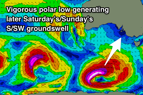
Conditions will remain great though a little windy on Saturday with fresh N/NE winds, with a new long-period S/SW groundswell expected late in the day, peaking Sunday morning.
This will be generated by another vigorous polar low, producing a fetch of severe-gale to storm-force W/SW winds in our south swell window Thursday.
This swell looks to be the biggest across our region, kicking to 3ft off Middleton late in the day and peaking Sunday morning to 3-5ft. Winds look to swing from the NW to SW, but we'll review this on Wednesday.
Moving into early next week and we'll see swells arriving more from the W/SW as a strong node of the Long Wave Trough in the south-east Indian Ocean projects strong storms through our western swell window. More on this Wednesday.

