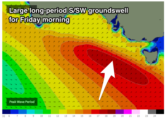
Large powerful S/SW groundswell Friday morning with workable winds
South Australian Forecast by Craig Brokensha (issued Wednesday 16th May)
Best Days: Thursday morning South Coast, Friday morning South Coast, Sunday morning South Coast
Recap
More tiny Mid Coast waves yesterday with small lumpy leftovers down South ahead of a mid-morning onshore change.
Today a mix of new W/SW and SW swell have provided better waves across both coasts with variable winds and lumpy 3ft sets off Middleton and 1-1.5ft waves on the Mid that has now kicked to 2ft with the incoming tide this afternoon.


Today’s Forecaster Notes are brought to you by Rip Curl
This weekend and next week (May 17 – 20)
These notes will be brief as Ben’s on holidays.
Today's mix of swells will ease back through tomorrow, dropping from 2ft to possibly 3ft off Middleton tomorrow morning and 1-1.5ft on the Mid Coast with early light winds, freshening from the W/SW through the day.
Very late in the day signs of new long-period S/SW groundswell should be seen.
Satellite observations of the severe low linked to this swell are looking great with storm-force W'ly winds being generated in our southern swell window.
 We'll see this low continuing to produce severe-gale to storm-force W/SW winds in our southern swell window this morning, before weakening slightly and passing under Tassie this evening.
A large long-period S/SW groundswell may be seen late tomorrow, but Friday morning should reveal large 5-6ft sets across most exposed breaks down South, easing through the day and down further from 3ft to occasionally 4ft Saturday morning.
The Mid Coast will become tiny with the southerly swell direction not really creating any size at all.
Winds on Friday look funky, but an early W/NW'ly likely across the South Coast before giving into a S/SW change late morning.
Come Saturday lingering onshore winds from the S/SE look to spoil conditions down South, cleaner Sunday with a morning W/NW'ly but smaller easing surf from 2ft+.
Looking into next week and we've got plenty of moderate to large sized S/SW groundswell on the cards as a strong node of the Long Wave Trough stalls over the Tasman Sea, directing strong fronts up through our southern swell window into Tasmania. Winds look suss though, but we'll review this Friday.

