Fun waves across both coasts ahead of large stormy conditions
South Australian Forecast by Craig Brokensha (issued Monday 7th May)
Best Days: South Coast tomorrow morning, Mid Coast later in the day, South Coast Wednesday
Recap
Light winds and fun 2ft waves across the Mid Coast Saturday, back to a tiny and bumpy 1-1.5ft on Sunday.
The South Coast was great both Saturday and Sunday with a drop in swell back to the 3ft+ range off Middleton on the former, hanging in around 2-3ft Sunday.
This morning a new SW groundswell has come in a little under expectations, with sets struggling to reach 3ft off Middleton under a strengthening N tending N/NW breeze. The Mid Coast held around 1-2ft but with deteriorating conditions.
Today’s Forecaster Notes are brought to you by Rip Curl
This week and weekend (May 8 – 13)
Today's SW groundswell will ease through tomorrow, though some less consistent reinforcing groundswell should provide 2-3ft sets off Middleton, produced late last week by a storm south-west of WA. A variable morning wind will create OK conditions but there may be some leftover lump from overnight onshores.
The Mid Coast is expected to drop back to 1-1.5ft, but some new W/SW swell is due from the current trough approaching from the west, with a great fetch of W/SW gales generated under WA yesterday afternoon.
We should see this swell kick to 1-2ft later tomorrow, while Wednesday morning should see a peak to a more consistent 2ft.
 The South Coast is expected to drop in size through the morning Wednesday from 2ft to maybe 3ft off Middleton, but into the afternoon and more so Thursday some new SW groundswell is due.
The first pulse for Wednesday afternoon will be generated by a pre-frontal fetch of W/NW gales, with Middleton expected to hang in around 2-3ft into the evening.
The secondary better SW groundswell for Thursday will be produced by a stronger fetch of W/SW gales pushing through our swell window tomorrow and Wednesday.
This storm will actually be the final stages of a much stronger polar low that moved through the Indian Ocean over the weekend, generating a long-period and inconsistent swell for Friday/Saturday.
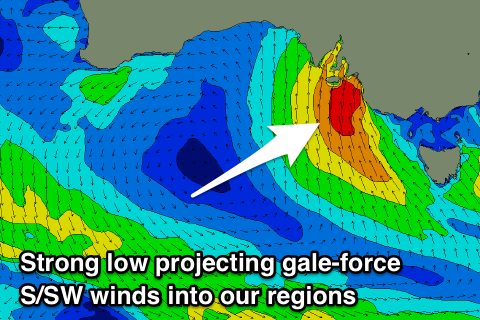
Unfortunately the remnants of the storm linked to Thursday's swell will combine with a polar front moving up from the polar shelf, projecting the front directly into our region on Thursday.
This will bring strong to gale-force S/SW winds on Thursday and a stormy increase in S/SW windswell, building to the 6ft+ range.
Strong onshore S/SW winds will persist through Friday and Saturday as a low spawns off the cold front, stalling over south-east Victoria through the end of the week before starting to move off to the east during the weekend.
This will spoil any groundswell due across the region, while continuing to generate moderate to large levels of stormy S'ly swell for the South Coast.
The Mid Coast will see choppy surf to 2ft on Thursday with strong S/SW winds, cross-offshore and tiny into Friday and the weekend.
Longer term we should see this pattern settle down into mid-next week with a return to more favourable winds and a fun looking swell, but more on this Wednesday.


Comments
Looks like the new swell is already here, and punching above its weight.

Yeah, a bit bigger than expected and earlier.
Yowza.

Jeez, it's epic on the Mid this afternoon.

Falling out of the sky!