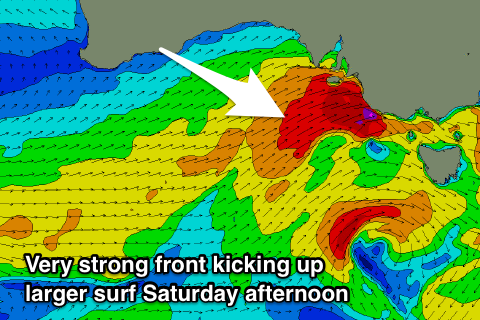
Fun waves to end the week down South, windy and stormy into Saturday, workable down South Sunday
South Australian Forecast by Craig Brokensha (issued Wednesday 11th April)
Best Days: South Coast tomorrow and Friday mornings, stormy spots on the Mid Coast Saturday afternoon, South Coast Sunday and Monday morning
Recap
Good fun waves across South Coast swell magnets yesterday morning with clean conditions and a bit of leftover swell ahead of an afternoon SE change. The Mid Coast was tiny and peaky.
This morning the South Coast was small to tiny and with improving winds before sea breezes took over, while the Mid Coast was tiny again, but the Cape du Couedic wave buoy is picking up the new W/SW swell and we should see sets pushing 2ft this afternoon, though with less than idea winds.
Today’s Forecaster Notes are brought to you by Rip Curl
This week and weekend (Apr 12 - 15)
This afternoon's increase in W/SW groundswell is the first of two pulses due over the coming 24 hours, with the second which will be better aligned for the South Coast expected to fill in tomorrow.
This should see Middleton coming in at a better 3ft on the sets through the day, with 2ft waves continuing across the Mid Coast swell magnets and winds now only look favourable for the South Coast.
A morning W/NW-NW breeze should hold into the early afternoon, shifting W/SW at some stage, while Friday will see the swell easing on both coasts with a gusty NW wind, strengthening and tending W/NW later.
 This strengthening W/NW breeze will linked to a strong mid-latitude low pushing through the Bight, kicking up a buildingNW windswell Friday to at least 2ft, if not 2-3ft by dark on the Mid Coast.
This front proper will generate 3ft or so of W/SW groundswell Saturday on the Mid Coast, but an event stronger front pushing into us will kick up some larger stormy windswell that will likely see 4ft sets into the afternoon.
The South Coast isn't expected to see much size off the initial W/SW swell pulse, coming in around 3ft Saturday morning, but the secondary front will project gale to severe-gale W/SW winds into the region, kicking up a large late pulse of SW swell to a choppy 6ft or so off Middleton along with strong W/SW winds.
We're likely to see things settled down a little Sunday as we fall in between fronts and winds hold fresh from the W/NW most of the day, favouring protected spots down South.
Into Tuesday/Wednesday though a final large pulse of S/SW groundswell is expected as a broad, elongated fetch of gale to severe-gale SW winds develop through the Southern Ocean in our southern swell window. More on this Friday.

