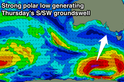
Improving conditions late week with a fun S/SW groundswell
South Australian Forecast by Craig Brokensha (issued Friday 2nd March)
Best Days: Thursday morning, Friday morning swell magnets
Recap
The South Coast wasn't too bad Saturday morning with a light onshore wind and good sized swell in the 3ft range off Middleton, while the Mid Coast was tiny and back to 0.5-1ft.
Sunday was less inspiring with a drop in swell and a bit more strength to the morning onshore wind down South, while the Mid Coast was a tiny 0.5ft, pulsing a little later in the day to 1ft+ with a new swell.
This swell has held in at 0.5-1ft this morning on the Mid, while the South Coast was small and poor.
Today’s Forecaster Notes are brought to you by Rip Curl
This week and weekend (Mar 6 - 11)
As touched on last Friday, this coming week isn't too flash at all for surfing, though we've got a slight upgrade in the S/SW groundswell due on Thursday.
Into tomorrow we'll see today's spike in SW swell easing with poor and fresh SE tending S/SE winds. The Mid Coast will be tiny to flat.
These SE-S/SE winds will kick up a small weak S/SE windswell on Wednesday and winds will tend a little more E/SE-E but conditions will remain poor.
Into Thursday we'll see a new long-period S/SW groundswell filling in, generated by a developing polar low south of the country this afternoon and evening. A fetch of severe-gale W/SW winds will be generated late in our swell window, but we should still see a fun increase in size, especially considering the weak swells due tomorrow and Wednesday.
 Middleton should offer see good 2-3ft sets on Thursday with a touch more size at Waits and Parsons and winds will swing E/NE-NE creating cleaner conditions ahead of sea breezes.
The swell will drop back from a small 2ft Friday with better NE-N/NE winds across the South Coast.
This swell won't impact the Mid with it being too south in direction.
Into the weekend no new swell is due, though conditions will be super clean Saturday morning. Even Waits will struggle to get above 1ft.
A onshore change Sunday will bring an increase in S/SE windswell, but of greater importance is the swell activity due into next week.
A node of the Long Wave Trough is expected to strengthen across Victoria next week, bringing with it an increase in storm activity through the Southern Ocean. We're due to see moderate to large pulses of swell through next week, but winds look average for the South Coast at this stage.
More in this Wednesday.

