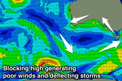
Poor summer period
South Australian Forecast by Craig Brokensha (issued Monday 29th January)
Best Days: Mid Coast on a fun board tomorrow
Recap
Good fun waves across the South Coast swell magnets Saturday, tiny into Sunday and hot. Today the swell has bottomed out with an onshore wind.
The Mid Coast was tiny all weekend, and this morning around a similar size though with a onshore wind. We should see a new mid-period W/SW swell kicking later in the day on the Mid to 1-1.5ft and these S/SE winds will create favourable conditions.
Today’s Forecaster Notes are brought to you by Rip Curl.
This week and weekend (Jan 30 – Feb 4)
Settle in for a poor run of conditions over the coming period, as a strong slow moving high pushes into the Bight, stalling as fronts push up past its south-east flank, bringing relentless onshore winds.
 These S/SE winds will also upwell cold water across the South Coast, so you'll need a bit of extra rubber if braving the summer slop.
Later today's W/SW swell is expected to peak tomorrow across the Mid Coast to 1-2ft on the favourable parts of the tide, while the South Coast will see a mix of S/SE windswell coming in at a junky 3ft+ or so with strong S/SE winds.
The W/SW swell will ease through Wednesday, fading from a tiny 1ft+ on the Mid Coast, while the South Coast will remain a similar size with the gusty SE-S/SE winds and junky windswell.
Into the end of the week we may see winds tend a little more E/SE Thursday and Friday mornings but this will continue to create poor conditions with no decent groundswell.
Unfortunately there'll be no let up in the onshore E/SE-SE winds through the weekend, with a smaller weaker S/SE windswell and flat conditions across the Mid Coast.
We're expected to see the stubborn high moving slowly east through next week resulting in an improvement in winds, but there'll be no swell due to the blocking effects of the high. More on when this will change on Wednesday.


Comments
Any updates on the triggs cam?