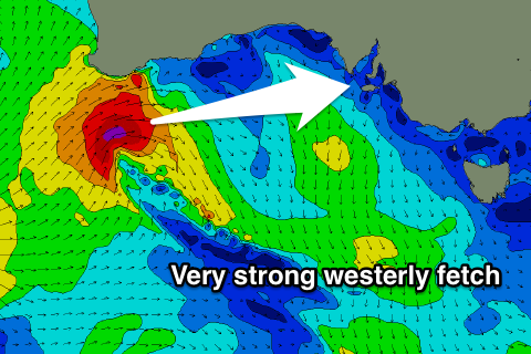
Strong west swell for Sunday
South Australian Forecast by Craig Brokensha (issued Friday 5th January)
Best Days: South Coast Saturday morning, Mid Coast Sunday through Wednesday, South Coast Wednesday morning and Thursday morning
Recap
Good clean waves across the South Coast yesterday morning with a good S/SW groundswell to 3ft+ off Middleton. The Mid Coast was also good with clean 1ft waves through the morning.
Today the surf was a bit smaller but fun down South again with light offshore winds, while the Mid Coast was back to 0.5ft with the rare bigger one.
Today’s Forecaster Notes are brought to you by Rip Curl
This week and weekend (Jan 6 – 12)
Into this afternoon we should see a reinforcing S/SW groundswell filling in down South, generated by a small but strong front passing through our southern swell window the last couple of days.
This swell is due to peak overnight but keep fun waves hitting swell magnets across the South Coast tomorrow in the 2-3ft range, with smaller 1-2ft waves off Middleton, easing during the day. The Mid Coast will be tiny.
 Conditions will be great early tomorrow with a fresh and straight offshore N'ly wind, but a swing to the NW is due late morning ahead of a SW change early afternoon.
This change will be associated with a strong front pushing in from the west, with it currently intensifying off the South West coast of WA.
We're still set to see a tight and very intense fetch of severe-gale to near storm-force W/SW winds projected through the Mid Coast's swell window initially before the front weakens and broadens on approach to us.
We should see a great W/SW groundswell pulse for Sunday across the Mid Coast, peaking into the afternoon with the incoming tide.
The Mid Coast should be around 1-2ft through the morning, kicking to 2-3ft with the incoming tide and under SE tending S/SE winds. If there is a sea breeze it'll swing back S/SE later in the evening.
The South Coast is expected to be small to tiny and onshore, with only a late increase in size to 2ft+ across Middleton.
A secondary busty of W/SW gales pushing in under WA tomorrow should produce a reinforcing W/SW swell for Monday morning, which will be better aligned for the South Coast.
We should see the Mid Coast hanging in around 2ft, if not for the odd bigger one with the afternoon incoming tide, while Middleton should persist around 2-3ft. A S/SE tending SW breeze will continue to favour the Mid Coast, while the South Coast will be average.
Another less consistent reinforcing SW swell is expected to fill in Tuesday, generated by a more distant polar front that's currently east of the Heard Island region.
While less consistent, 1-2ft waves are expected to persist across Middleton Tuesday, easing Wednesday, while the South Coast looks to maintain 2ft to occasionally 3ft.
Winds look best for the Mid Coast Tuesday, and favourable for both locations Wednesday, but more on this Monday. Have a great weekend!


Comments
Yesterday's 40 degree temps have eased to a pleasant 25 degrees, winds are SE and unusually light (no sea breeze yet along the Mid), and there's a clean 2-3ft groundswell pushing through the gulf - forecast in Craig's Wednesday notes as "great W/SW swell for Sunday" - yet there's not a single person in the water at the Hump, despite the fact that the surfcam looks right at it. Sure, it ain't epic, but... huh?


However, there are plenty of crew at the Rivermouth (swimmers and surfers), despite the surf being a little smaller and the quality a little more patchy. These two images are of the same wave (see old mate fanging the brief section in the first one).


Should be a cracking arvo on the Mid.
Nice waves this afternoon, good viewing on the new Christies Beach surfcam too.


